Here at The Mapping Network, we specialize in accurately mapping bodies of water, calculating the water volume, collecting sediment depth samples at critical areas and monitoring the distribution of sediment over time. We have a nationwide group of professionals specializing in all facets of lake management. If you are serious about maintaining a high-quality lake or pond, be sure you have the ability to make the best decisions, get your lake mapped by the professionals at The Mapping Network. Give us a call or send an e-mail to find out more details.
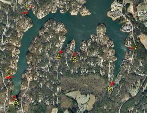
[caption id="attachment_2614" align="aligncenter" width="300" caption="Locations of sediment depth points collected. Each cover where a creek entered the lake was surveyed for sedimentation. The results of this project will assist lake managers in creating dredging plans."]
 [/caption]
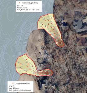
[caption id="attachment_2615" align="aligncenter" width="278" caption="Map displaying sediment depths with color-shading to visualize the areas of high sedimentation."]
 [/caption]
contact: Steve Bartosh
phone: (402) 241-8177
e-mail: info@themappingnetwork.com
website: www.themappingnetwork.com
A Nationwide Network of GPS Mapping Professionals

No comments:
Post a Comment