Friday, April 29, 2011

CABELA’S PARTNERS WITH THE MAPPING NETWORK

Cabela’s joins forces with The Mapping Network for nationwide lake and land mapping

The Mapping Network is proud to announce their firm has been chosen by Cabela’s, the World’s Foremost Outfitter, as a Landowner Services provider for Cabela’s Trophy Properties throughout the United States.
Cabela’s Landowner Service providers help property owners plan, develop, and maintain wildlife habitat and aquatic resources on their property.  Private land owners, property managers, governmental organizations, hunting clubs, and outfitters are some of the customers who utilize landowner services.   “Cabela’s Trophy Properties”, as Steve Bartosh explained, “is a network of experts who work together to help those who buy, sell, manage, develop and own recreational properties across North America”.

It is critical to know the local wildlife and aquatic needs in order to make the right land and water management decisions.  Staff at The Mapping Network have been helping people who have owned or managed recreational properties since 1999, and now they will be able to apply the benefit of Cabela’s outdoor expertise to the properties they serve.  Let The Mapping Network use their knowledge and equipment to help maximize your property.

Cabela’s Trophy Properties is excited to have The Mapping Network as one of their Landowner Service Providers.  They invite you to visit the Cabela’s Trophy Properties website at www.CabelasTrophyProperties.com. If you are a property owner or manager and want to know about the landowner services available to you through this program you can call Steve Bartosh at (402) 241-8177 or email him at info@themappingnetwork.com

About Cabela’s Trophy Properties LLC: Cabela’s Trophy Properties LLC, a wholly-owned subsidiary of Cabela’s Corp. (NYSE: CAB), is a global network of experts who serve the recreational industry. For more information please call 1-800-535-6007 or visit www.CabelasTrophyProperties.com.

The Mapping Network provides the highest quality and is the most affordable bathymetric mapping system on the market today.  If you are serious about maintaining  a high-quality lake or pond, be sure you have the ability to make the best decisions,  get your lake mapped by the professionals at The Mapping Network.   Give us a call or send an e-mail to find out more details.

phone:  (402) 241-8177
e-mail: info@themappingnetwork.com
website: www.themappingnetwork.com
A Nationwide Network of GPS Mapping Professionals

3D Color-shaded depth map showing the unique charasteristics under the surface of a lake

Real Estate in the Midwest in Appreciating Quickly

By Chris Bober, Sales Associate for Premier Outdoor Properties, licensed in Nebraska and Kansas

Midwest land is appreciating at an astounding pace. Land values in the Midwest are increasing as the national inflation rate lingers around 2 percent. Land is still in strong demand for both agricultural and recreational properties (i.e. farms/ranches, hunting and fishing properties, river/lake frontages, equestrian facilities and executive acreages) making NOW a favorable seller’s market. If you have been considering selling all, or part, of your property, now is an excellent time to do so.

Selling/Exchanging land may allow you to take advantage of tax exchange laws to defer capital gain taxes on investment property. Furthermore, it provides you with an opportunity to reinvest in other properties or plan for retirement. With a strong demand and little for sale, today’s market creates a distinct advantage for the seller. It provides the seller flexibility and the ability to hold for the right deal. Nonetheless, there are many reasons to sell your land today and many benefits you can take advantage of.

Using a specialist in recreational real estate can provide a seller with the tools they need to realize the benefits of today’s real estate market in the Midwest. Premier Outdoor Properties has marketing platforms and expertise to give your property the exposure it needs and deserves. Studies have shown that over 90% of buyers begin their search for property online. Our listings may be viewed on more than 350 websites including LandWatch, Lands of America, Field & Stream, Cabela’s Trophy Properties, and of course, Premier Outdoor Properties, Inc. We have spent a lifetime enjoying the outdoors making us experts in the field. We have tools and experience that provide our clients the service and results they deserve.

Whether buyers are investing or looking for hunting/fishing land, one thing is certain; LAND IS IN DEMAND! So, if you are thinking of selling your land right now, do it with a professional. Recreational Real Estate specialists can help you sell your land properly and maximize your return on investment.

Lets Experience the Outdoors Together!

About the author

Chris Bober

Chris Bober is a Sales Associate licensed in Nebraska and Kansas. An All American football player at the University of Nebraska-Omaha, Chris played eight years in the NFL for the New York Giants and Kansas City Chiefs. After completing Math & Engineering degrees at UNO, Chris attended business school at Harvard and the Kellogg School of Management. Retiring from the NFL in 2008, he successfully started his own custom apparel business, but the call of the outdoors drew him to Premier Outdoor Properties. Born and raised in Omaha Nebraska, Chris’ passion for the outdoors started at an early age helping his dad teach Nebraska Hunter Safety Certification and training bird dogs for the National Field Trials. He has enjoyed hunting and fishing throughout North America. Whether it’s Muskie fishing in pristine Canadian waters, turkey hunting in upstate New York, big game hunting in the Rocky Mountains, or bass fishing on his own lake, Chris is always seeking the next challenge. If you are looking to buy or sell recreational property Chris Bober has the knowledge and the skill to make it happen. As a property owner himself, Chris’ valuable experience in the purchasing and development of recreational land is an added bonus for his clients. Known for his tireless work ethic and attention to detail, Chris combines a lifetime of outdoor experience and a commitment to excellence that is hard to match.

Nebraska Land For Sale – Cabela’s Trophy Properties


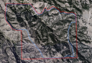
Here is an impressive 720 acres of breathtaking real estate.  This land is 80% tree covered.  East Boggy Creek starts in the canyons, there is also a dam on the creek.  Mule deer and Merriams Wild Turkey frequent the property and elk travel through this place.  There are huge elevation changes on this land and three states can be viewed from the highest points (Nebraska, Wyoming and South Dakota).  If you are looking for a getaway spot, then this is it.  There are extensive roads and trails throughout the property.  There is a high fence around approximately 600 acres.  

For More information on this listing click here:  http://www.lashleyland.com/realestate/east_boggy_creek.html
 
View other Nebraska hunting properties from Lashley Land: www.lashleyland.com

This property is also listed on the exclusive Cabela’s Trophy Properties website.

Contact Listing Agent
Scott Saults
308-289-1383
scott@lashleyland.com
 

Aerial map of "East Boggy Creek" for sale in Sioux County, Nebraska

Mike Lashley and Lashley Land & Recreational Brokers – A Real Estate Service Like No Other!
Nebraska Farm and Ranch Land For Sale – Cabela’s Trophy Properties
Nebraska River Land For Sale – Waterfowl, Deer and Turkey Hunting

All aerial, topography and location maps provided by The Mapping Network: www.TheMappingNetwork.com
A Nationwide Network of GPS Mapping Professionals
 
Need a Large Wall Map for your property or hunting area? The Mapping Network provides a low cost mapping product for the outdoor enthusiast!  Just let us know what area you want and we will print and ship a beautiful full-color wall map using the best aerial imagery available.

Create your own Aerial Maps here: Make My Own Map

The Mapping Network is proud to announce their firm has been chosen by Cabela’s, the World’s Foremost Outfitter, as a Landowner Services provider for Cabela’s Trophy Properties throughout the United States.  Visit us on the Cabela’s Trophy Properties website >> click here

Sediment Problems in Your Lake? Start With a Lake Map!

Save Significant Money on Dredging Projects with The Mapping Network!

The Mapping Network recently completed a mapping project for a large-scale home owners association in Arkansas.  The large lake had 21 coves and several homeowners were having difficulties accessing their dock due to sedimentation.  Here were some of the questions the HOA management team had:
- where is the highest sedimentation occurring?
- how much fluffy sediment (in cubic yards) is in each cove?
- if the lake is drawn down 5 ft, what would the shoreline look like?
- how much water (gallons and acre-ft) is in the lake?
- if we make each cove a minimum of 4 feet deep for boat access how much material do we need to remove?
- by undertaking this mapping process will it save us money in the end?

The overall goal of the lake mapping project was to survey each cove for future dredging along with the creation of an accurate map of the entire lake.  The lake had 21 coves and The Mapping Network collected water depths over the entire lake and fluffy sediment levels for all areas under 10 feet of water.
3D models were generated to show how much sediment had accumulated in each cove.  Contour maps were also made for each cove and given to the lake manager and engineer to review for dredging planning.  The Mapping Network then created cut-fill calculations and maps based on the specifications of the lake manager.  The HOA then used this information as part of the bid package given to dredging companies.  Presenting the precise plans took out the guess work and kept all the dredging contractors on task and it is projected to save the HOA an estimated $5,000-$12,000 per cove!  An incredible cost savings when compiled over 21 coves.

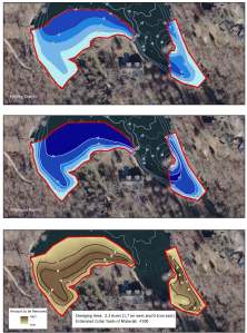
In the example maps below, The Mapping Network located the areas where the current depth was less than four feet, which was the dredging zone.  The mapping techniques utilized in this project helped the HOA accurately calculate and isolate areas of high sedimentation for removal and helped the property manager budget accordingly.

The bottom line – This powerful information allows for smart management and planning decisions and will serve as a baseline for future projects.  A great value!

A series of maps showing the seleceted area for dredging. The current lake bathymetry (top) and the post-dredge contours (middle) are shown in blue shading. A cut-fill model (bottom) shows areas of cut needed to reach the goal.
A series of maps showing the selected area for dredging. The current lake bathymetry (top) and the post-dredge contours (middle) are shown in blue shading. A cut-fill model (bottom) shows areas of cut needed to reach the goal.

The Mapping Network provides the highest quality and is the most affordable bathymetric mapping system on the market today.  If you are serious about maintaining  a high-quality lake or pond, be sure you have the ability to make the best decisions,  get your lake mapped by the professionals at The Mapping Network.   Give us a call or send an e-mail to find out more details.
phone:  (402) 241-8177
e-mail: info@themappingnetwork.com
website: www.themappingnetwork.com

Friday, April 15, 2011

Kansas City HOA Lake Map Project

The Mapping Network and Absolute Natural Resources teamed up for a mapping project on the western edge of Kansas City, Kansas.  The client, a Home Owner Association, requested the creation of a detailed property and lake map which will then be distributed throughout the community.  Mapping the lake on the property allows for proper management of largemouth bass, crappie, blue gill and catfish populations by knowing exact depths and acreage for stocking densities and vegetation control.  Over 30 sediment depth samples were also collected in the field and placed on a separate map.  The maps are a handy tool for families and guests to the community by showing all trails and fishing hot spots.

Absolute Natural Resources provides extensive land and habitat GPS mapping services involving the use of complex data collection methods, state of the art GIS and GPS technology and satellite imagery.  Absolute Natural Resources offers a variety of mapping services and products for real estate professionals, private landowners, fishing and hunting clubs, habitat and lake developers, hunting lease managers, timber management firms, and recreational land companies.

Located in Denver, Colorado, Absolute Natural Resources has the experience to handle mapping projects in the steep terrain of the Rocky Mountains to the gentle hills of the Great Plains region.  Common client requests include, but are not limited to, aquatic vegetation beds, wetlands, streams, irrigation canals, inlet and outlet features, dam facilities, habitat structures, boat ramps, fishing piers, duck blinds, waterfowl nests and site-specific channels.

More information on Absolute Natural Resources, LLC can be found on their website:  www.anrwildlife.com

 
Aerial map showing lake depths, trails, and other features of the lake community
 
The Mapping Network provides the highest quality and is the most affordable bathymetric mapping system on the market today.  If you are serious about maintaining  a high-quality lake or pond, be sure you have the ability to make the best decisions,  get your lake mapped by the professionals at The Mapping Network.   Give us a call or send an e-mail to find out more details.
phone:  (402) 241-8177
e-mail: info@themappingnetwork.com
website: www.themappingnetwork.com
A Nationwide Network of GPS Mapping Professionals