Wednesday, July 27, 2011

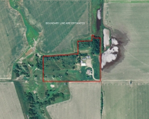
South Table Ranch is located adjacent to the North Platte River and Garden County Game Refuge where Duck and Goose hunting are second to none.  This property will make a great starter ranch with plenty of winter protection and an abundance of grass. The owner states that the ranch can run 35–40 cows year round. This place would also be a great place to winter a group of cows. With the close proximity to the North Platte River valley – abundant corn fields could be available for winter feed. This property features the following:

• Submersible well that furnishes water for the house and livestock water in the corral.

• CRP income on the 46.7 acres stated above becomes available in 2012. Remaining acres is in pasture land.

• Large mature trees around the home site and a newer established row of trees in the pastures.

Hunting and Recreational opportunities
• Deer
• Coyotes
• Elk
• Waterfowl

Contact Scott for more information regarding location and pricing:  308-289-1383 or scott@lashleyland.com


For More information on this listing click here:  http://www.lashleyland.com/realestate/southtable_ranch.html


View other Nebraska hunting properties from Lashley Land: www.lashleyland.com

This property is also listed on the exclusive Cabela’s Trophy Properties website.


Contact Listing Agent
Scott Saults
308-289-1383
scott@lashleyland.com


[caption id="attachment_2536" align="aligncenter" width="300" caption="Aerial map of "South Table Ranch" for sale in Garden County, Nebraska"][/caption]


Mike Lashley and Lashley Land & Recreational Brokers – A Real Estate Service Like No Other!


Nebraska Farm and Ranch Land For Sale – Cabela’s Trophy Properties


Nebraska River Land For Sale – Waterfowl, Deer and Turkey Hunting

All aerial, topography and location maps provided by The Mapping Network: www.TheMappingNetwork.com

A Nationwide Network of GPS Mapping Professionals
Check out The Mapping Network on Facebook for more examples and success stories!


The Mapping Network is proud to announce their firm has been chosen by Cabela’s, the World’s Foremost Outfitter, as a Landowner Services provider for Cabela’s Trophy Properties throughout the United States.  Visit us on the Cabela’s Trophy Properties website >> click here


Tuesday, July 26, 2011

The Mapping Network and lake mapping partner, The Pond Connection, have teamed up to map a lake for community lake in Westchester County, New York.   The primary purpose of the lake mapping project was to locate ideal places for fish structure and to make other habitat improvements.  Understanding the true nature of the lake bottom will allow biologists to maximize the fishery for lake residents.  Also, during the lake survey large boulders and rock walls were identified and noted for safety purposes.

[caption id="attachment_2525" align="aligncenter" width="209" caption="Contour map generated by The Mapping Network for a Lake in New York."] [/caption]

Located in Newtown, Connecticut, The Pond Connection is a full service pond and lake management company. They have been servicing clients in the New York Tri-State area for nineteen years. The Pond Connection offers many long term and natural solutions for problem lakes and ponds.

How The Pond Connection Utilizes Lake Mapping...

Cost effective management of a lake or pond requires a thorough understanding of the aquatic resource. It is critical to know the exact acreage, depths and water volume of a lake to make the right management decisions, including fish species selection, stocking densities, habitat placement, algae and aquatic weed control, and lake dredging requirements. Our 3D map of your pond or lake will provide the information needed for optimal enhancement, maintenance and enjoyment.

In addition to our primary pond and lake mapping services (i.e., the contour and 3D formats), we also offer comprehensive and detailed mapping of bottom sediment. The sediment map, which illustrates site-specific sediment depths and volumes, can be used to construct accurate lake dredging plans. For specialized needs, we can also map various features of the resource. These may include, but not limited to, aquatic vegetation beds, wetlands, streams, irrigation canals, inlet and outlet features, dam facilities, habitat structures, boat ramps and fishing piers. These features can be added to each type of map, depending upon the client's needs. Our specialized lake mapping service provides the detailed, accurate information landowners and property managers need to maximize their lakes' potential.

Clients can choose to receive various formats of maps, including high quality printed maps and large wall maps. Using highly specialized equipment, our certified technicians collect data in the field, which are then analyzed and processed by professional GIS specialists; using the best available printing equipment and media.

Services and Products Provided By The Pond Connection:

  • Lake and Pond Consultation

  • Seasonal Maintenance Contracts

  • Full Service Sales and Installation Distributor for:

  • Aqua-Master Fountains Aerators

  • Kasco Marine Aeration Equipment

  • Keeton Solar  Aeration Systems

  • Otterbine Fountains and Aerators

  • Biological Controls for Ponds and Lakes

  • Herbicide and Algaecide Treatments

  • Federal and State Aquatic Permitting

  • PHOSLOCK

  • Lake Mapping

  • Dredging Permits and Dredging

  • Invasive Plants Control

  • Buffer Zone Planting and Maintenance

  • Irrigation Water Testing

  • Swimming Pond and Lake Water Testing

  • Fish Stocking and Population Management

  • Pond and Lake Electro Shocking

  • Marina Slip De-Icers

  • Pond and Lake Draw Downs

  • Life Line Safety Equipment

  • EZ-docks

  • Pro-Skim Skimmers

  • FWM docks

  • Water testing

  • Triploid Grass Carp

  • LED Pond and Water Feature Lighting

  • Seasonal Aerator / Fountain Removal, Storage and Spring Start-Up


Give The Pond Connection a call or visit their website to find out more information.

phone: 1-800-305-3277

e-mail:  pondconnection@gmail.com

website:  http://thepondconnection.com


The Pond and Lake Connection

Note:  A full list of certified members of The Mapping Network is found on the right-hand side of the blog under “Partners”


The Mapping Network:  www.TheMappingNetwork.com

A Nationwide Network of GPS Mapping Professionals

Check out The Mapping Network on Facebook for more examples and success stories!

Monday, July 25, 2011

A Year of Flooding – How it Effects Your Lake

With the current Missouri River flooding disaster and earlier Mississippi River flooding occurring through much of the middle of the country we are hearing a lot about terms like cubic feet per second, carrying capacity, inflow, outflows, surcharge, and US Army Corps of Engineers flood inundation maps.   There is obviously considerable loss of  property and the length and scale of this disaster are yet to be known.

As rivers (both large and small) increase levels and change course there are extremely high amounts of sediment being moved by the flooding.  If you live on a lake that is fed by a creek or river, there is a high need to monitor and map out sediment accumulation.

Here at The Mapping Network, we specialize in accurately mapping bodies of water, calculating the water volume, collecting sediment depth samples at critical areas and monitoring the distribution of sediment over time.  We have a nationwide group of professionals specializing in all facets of lake management.   If you are serious about maintaining  a high-quality lake or pond, be sure you have the ability to make the best decisions,  get your lake mapped by the professionals at The Mapping Network.   Give us a call or send an e-mail to find out more details.

phone:  (402) 241-8177
e-mail: info@themappingnetwork.com
website: www.themappingnetwork.com
A Nationwide Network of GPS Mapping Professionals

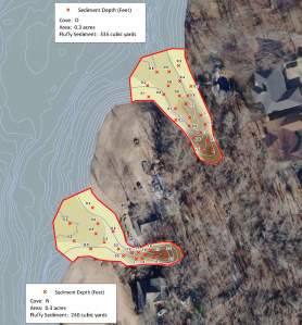
Map displaying sediment depths with color-shading to vizualize the areas of high sedimentation.
Map displaying sediment depths with color-shading to visualize the areas of high sedimentation.

Locations of sediment depth points collected. Each cover where a creek entered the lake was surveyed for sedimentation. The results of this project will assist lake managers in creating dredging plans.

Elk Creek Ranch in Oregon – Cabela’s Trophy Properties

Elk Creek Ranch – Oregon Hunting Land For Sale

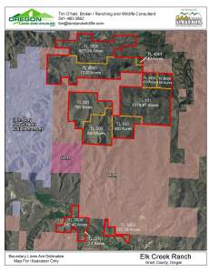
We are initially marketing 2300 acres of this Beautiful ELK CREEK RANCH. The lush hay ground sits on the John Day River just west of Dayville, Oregon. There is an additional +3900 Deeded Acres, a 3000 Acre BLM permit and additional homes and hunting cabin that could be added to this property (Same owner). With views that over look the Painted Hills and property that abuts The John Day Fossil Beds you will not believe your eyes. The hunting here is phenomenal with Mule Deer, Rocky Mt. Elk, Antelope, Black Bear, Turkeys, Chuckers, Quail and Waterfowl. Did we mention some of the best Small Mouth Bass fishing anywhere in the world on the John Day River. This is a real opportunity for someone to own a ranch from 2300 to 6200 acres in one of the best areas of Oregon. (Please refer to the map this price of $3,499,000 is for 2300 acres tax lots 100, 300, 301 and 2000) Call me and lets go tour this beautiful land. Timothy O Neil 541-480-3682
For More information on this listing click here: http://www.landandwildlife.com/HWY-26DAYVILLEOregon/62226/ORWildlife
View other hunting properties in Oregon from Oregon Land and Wildlife:  www.landandwildlife.com
Aerial Map of Elk Creek Ranch Hunting Land for Sale in Oregon
Aerial Map of Elk Creek Ranch Hunting Land for Sale in Union County, Oregon

LOT FEATURES: Big Game Hunting, Equestrian, Fishing, Upland Bird Hunting, Water Front, Waterfowl Hunting
 
Contact: Tim O’Neil, Broker, Rural Specialist
Direct Line:(541) 480-3682
Fax:(866) 610-0929
 
All aerial, topography and location maps provided by The Mapping Network:  www.TheMappingNetwork.com
A Nationwide Network of GPS Mapping Professionals
 
This property is also listed on the exclusive Cabela’s Trophy Properties website >>
CLICK FOR MORE INFORMATION

Cabela’s Trophy Properties: Flobert Springs Ranch & Reservoir

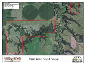
Property Summary:  Outdoor paradise with great investment potential!  Located in historic Antelope County, this 648 +/- acre tract has everything an outdoorsman wants & needs. Diverse habitat for deer, turkey, pheasant, quail, and dove hunting. Great fishing on the 13.42 +/- acre lake. Plus the potential of generating income from grazing, crop and hunting leases.

Estimated Acres:  648.71 +/- acres breakdown as follows: (428.9 +/- acres Pasture, 200.57 +/- acres Timber, 13.42 +/- acres Lake, 3 +/- acres Farmstead/Home site, 2.73 +/- acres Roads).

Location/Directions:  From Elgin, Nebraska – Drive north on Hwy 14 for about 5 miles. Turn right on 843rd St and head east 1.5 miles. Turn right and head south for 1/2 mile. Property is on the left.

Property Coordinates: 42.03329N, 98.0153W

Property Highlights:   A rare and unique mixed bag of hunting opportunities. The tail waters of Flobert Springs Reservoir populate a live creek that flows through thick timbered draws creating the perfect sanctuary for big bucks and long bearded gobblers. The wild grasses are teeming with pheasant, quail, and even some grouse.
-Constructed over 50 years ago, Flobert Springs Reservoir is fed by natural springs and holds lunker largemouth bass, slab crappie, pan-sized bluegill and catfish.  Carefully managed and protected by the landowners, this 13.42 +/- acre lake is a hidden gem.
-Appealing income potential!  This property is capable of generating annual income from grazing, crop and hunting leases. CRP is expiring in October 2011 allowing for the conversion of 70.9 +/- acres into tillable land.
-Situated overlooking the lake, the 926 +/- sf cabin is perfect for a weekend retreat or a base camp for hunting season. Store your boat, four wheeler, or tractor in the three stall storage building.
-For more information or showing call Chris Bober at Premier Outdoor Properties, (402)312-5076.

Estimated Income:
Grazing Income: $18,000
Hunting Leases:  $12,756
TOTAL ESTIMATED INCOME:  $30,756
Taxes: $5,758/year (2010)

For More information on this listing click here:  http://www.premieroutdoorproperties.com/viewlisting.php?returnstate=&searchstr=agentid%3D16&listingid=344

View other hunting properties in Kansas, Iowa and Nebraska from Premier Outdoor Properties:  www.premieroutdoorproperties.com

Aerial Map for Hunting Land For Sale in Antelope County, Nebraska
Contact Chris Bober for more information about this property:
Chris Bober Chris Bober
Cell: (402)312-5076
Office: (402)359-2212
Fax: (402)359-2220
ChrisBober@PremierOutdoorProperties.comAbout Chris |  View All of Chris’s Listings
All aerial, topography and location maps provided by The Mapping Network:  www.TheMappingNetwork.com
A Nationwide Network of GPS Mapping Professionals
 This property is also listed on the exclusive Cabela’s Trophy Properties website.

Lake Volume and Capacity Curves

GPS Lake Mapping Accurately Accounts for Current Water Capacity

It is critical to know the exact acreage and depth range of your lake to make sound management decisions.  Precision GPS lake mapping conducted by The Mapping Network utilizes highly accurate procedures and equipment for data collection.  Utilizing sub-foot accurate GPS units and hydro-acoustic depth-sounding equipment, our team logs data points for extremely accurate location mapping.  Hydro-acoustic depth sounding equipment measures depth with unparalleled accuracy. 

Our clients are able to accurately understand how much water is available in their lake at any number of water levels.  Best of all, this information is up-to-date and can be customized to any requirement.  Need to know how many gallons of water are available when the lake is at full pool?  How about if the water level is down 5, 10, or 15 feet?  We can even calculate the amount of water in certain depth ranges (example: volume for 5 to 6 feet).  Current, accurate results are our specialty.

A GPS Bathymetric Lake Map and Volume Analysis by The Mapping Network will help optimize your efforts to manage your lake or pond.
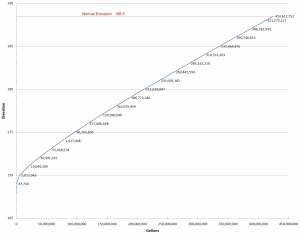
The Mapping Network offers a highly accurate "Volume Analysis" option for lakes.

Capacity Curve shows the relationship between water volume and elevation. Better understand the volume of your lake with The Mapping Network.

Please contact us for more information on how this service can assist you in managing your aquatic resource.

The Mapping Network:  www.TheMappingNetwork.com
A Nationwide Network of GPS Mapping Professionals

The Mapping Network provides the highest quality and is the most affordable bathymetric mapping system on the market today. If you are serious about maintaining a high-quality lake or pond, be sure you have the ability to make the best decisions, get your lake mapped by the professionals at The Mapping Network. Give us a call or send an e-mail to find out more details.
phone: (402) 241-8177
e-mail: info@themappingnetwork.com
website: www.themappingnetwork.com

Friday, July 22, 2011

Solitude Lake Management: Smith Mountain Lake Gets Tough on Hydrilla

Solitude Lake Management: Smith Mountain Lake Gets Tough on Hydrilla: "We are very excited to be working with our friends at Smith Mountain Lake to assist them with the overall lake management program for nuis..."
SŌLitude Lake Management®, a Lake Mapping Partner with The Mapping Network, offers the most technologically advanced lake mapping services available on the market, providing the most detailed and highest quality mapping products you can buy, for a very affordable price.   Click for examples of our lake mapping.

Check out The Mapping Network on Facebook for more examples and success stories!


Equipped with the very latest in GPS surface mapping, bathymetry, 3-D contour imaging, aerial and fly-over video resources and virtual underwater swim-view 3-D mapping, we are able to add layers of depth to the information our customers seek. Whether you are tracking sedimentation, planning for dredging, looking to improve your fishery, or simply looking to understand the overall size, volume, and bottom contour of your pond in order to make good management decisions, we have the tools you need to be successful.

Solitude Lake Management Website on Lake Mapping:  http://www.solitudelakemanagement.com/services/lake-mapping/


Contact SŌLitude Lake Management® here:  http://www.solitudelakemanagement.com/contact/

Find a Lake Mapping Service Provider Here:  Map My Lake


Questions about the lake mapping process and pricing?


E-mail us:  info@themappingnetwork.com

Thursday, July 21, 2011

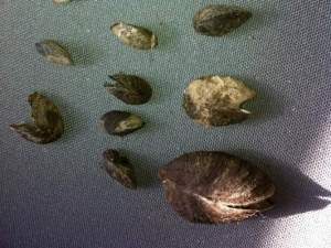
The refilling of Zorinsky Lake has begun after it was drained for seven months in an effort to kill off the invasive zebra mussel.

The Army Corps of Engineers closed the gates to the lake Tuesday.

Victory has been cautiously declared, but the zebra mussel is notoriously difficult to kill off. The goal behind draining the lake was to freeze out any living mussels. Because dirt clogged access to the drain, the lake was not completely emptied. As a result, it is possible that some mussels survived, especially around the 168th Street bridge, officials say.

Read the entire article here:  http://www.omaha.com/article/20110714/NEWS01/707149834/1031361.

[caption id="attachment_2473" align="aligncenter" width="300" caption="These zebra mussels were found at Zorinsky Lake this winter."][/caption]

The Mapping Network provides the highest quality and is the most affordable bathymetric mapping system on the market today.  We specialize in accurately mapping bodies of water, calculating the water volume, collecting sediment depth samples at critical areas and monitoring the distribution of sediment over time.  We have a nationwide group of professionals specializing in all facets of lake management.   If you are serious about maintaining  a high-quality lake or pond, be sure you have the ability to make the best decisions,  get your lake mapped by the professionals at The Mapping Network.   Give us a call or send an e-mail to find out more details.

phone: (402) 241-8177

e-mail: info@themappingnetwork.com

website: www.themappingnetwork.com
Just 25 minutes from North Platte - this property truly stands out from the others. This is an outstanding rural residential acreage in which the Sellers have just completed a remodel of the home. This property features the following:
3 Bedrooms / 2 Baths
Family Room on the main floor and Game Room in the basement
HVAC, Water Heater and Electrical Panel were updated in the 2010 renovation
Kitchen has all new hickory cabinets and tile flooring
Windows have been updated
Cleary Horse barn is very nice and includes a finished tack room, 4 box stalls and a feed room
Garage has an interior room that could be used as a workshop.
New flooring throughout including heated tile in the bathrooms
Pipe pens and riding arena

For More Information
Contact Listing Agent
Duane McClain 308-530-0221
duane@lashleyland.com


For More information on this listing click here:  http://www.lashleyland.com/realestate/wellfleet_acreage.html


View other Nebraska hunting properties from Lashley Land: www.lashleyland.com

This property is also listed on the exclusive Cabela’s Trophy Properties website.


[caption id="attachment_2465" align="aligncenter" width="300" caption="Aerial map of "Welfleet Acreage" for sale in Lincoln County, Nebraska"][/caption]


Mike Lashley and Lashley Land & Recreational Brokers – A Real Estate Service Like No Other!

Nebraska Farm and Ranch Land For Sale – Cabela’s Trophy Properties


Nebraska River Land For Sale – Waterfowl, Deer and Turkey Hunting

All aerial, topography and location maps provided by The Mapping Network: www.TheMappingNetwork.com

A Nationwide Network of GPS Mapping Professionals
 
Need a Large Wall Map for your property or hunting area? The Mapping Network provides a low cost mapping product for the outdoor enthusiast!  Just let us know what area you want and we will print and ship a beautiful full-color wall map using the best aerial imagery available.

Create your own Aerial Maps here: Make My Own Map


The Mapping Network is proud to announce their firm has been chosen by Cabela’s, the World’s Foremost Outfitter, as a Landowner Services provider for Cabela’s Trophy Properties throughout the United States.  Visit us on the Cabela’s Trophy Properties website >> click here

Friday, July 15, 2011

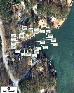
Greg Grimes with Aquatic Environmental Services, Inc., recently completed a GPS lake mapping project for a client in Georgia.  The purpose of this project involved mapping the current lake depths and sediment thickness of the coves for future dredging.  The mapping techniques utilized in this project helps Aquatic Environmental Services accurately calculate and isolate areas of high sedimentation for removal and helps the property manager budget accordingly.  This powerful information allows for smart management and planning decisions and will serve as a baseline for future projects.

The Mapping Network provides the highest quality and is the most affordable bathymetric mapping system on the market today.  We specialize in accurately mapping bodies of water, calculating the water volume, collecting sediment depth samples at critical areas and monitoring the distribution of sediment over time.  We have a nationwide group of professionals specializing in all facets of lake management.   If you are serious about maintaining  a high-quality lake or pond, be sure you have the ability to make the best decisions,  get your lake mapped by the professionals at The Mapping Network.   Give us a call or send an e-mail to find out more details.

phone: (402) 241-8177

e-mail: info@themappingnetwork.com

website: www.themappingnetwork.com

[caption id="attachment_2439" align="aligncenter" width="238" caption="Water depth and sediment thickness were recorded on the coves at this lake."]Water depth and sediment thickness were recorded on the coves at this lake.[/caption]

Aquatic Environmental Services, Inc offers a wide range of lake management and fisheries management services to residential, commercial, and private lake owners throughout Georgia and the southeast. We have been providing these quality services since 1996. AES has the experience and education necessary to provide unsurpassed lake and fishery services. We have selected only the best products available for resale to our customers. Since the year 2000 we have performed services on over 2000 bodies of water.

Aquatic Environmental Services, Inc now has two divisions. Our Lake Management Division (LMD) emphasis is on maximizing the aesthetic appeal of a body of water while our Fishery Management Division (FMD) travels the southeast helping our clients grow big fish. Please visit these pages to find out more specific information on how we can help you with your lake management.

Our staff is comprised of three degreed fishery biologists. Mike Rosa heads LMD and has his B.S. in Fisheries from the University of Georgia. Matthew Morgan is supervisor for FMD and obtained his degree from the famed fishery management program at Auburn University. Greg Grimes, President of AES, obtained his masters in Fisheries from the University of Georgia in 1998 at which time he began the expansion of AES that continues today.

More information on Aquatic Environmental Services, Inc can be found on their website: http://lakework.com

The Mapping Network: www.TheMappingNetwork.com

A Nationwide Network of GPS Mapping Professionals

Monday, July 11, 2011

Wow! An amazing grand old barn plus a magnificent home that has been completely remodeled.  This beautiful and immaculate property is conveniently located just 10 miles north of Gothenburg, Nebraska.  This property has it all:  beautiful home, grand barn, Quonset with a concrete floor and wired for 220, pole shed, 3 grain bins and plenty of grass for your horses. You will see white-tailed and mule deer, turkey, dove, pheasants, bobcat and even a 6 point bull elk has been spotted.  This could be your peaceful country home.  Seller requests showings to prequalified buyers only.


Contact Listing Agent For More Information
Lucy Thierer
308-539-4260
lucy@lashleyland.com


For More information on this listing click here:  http://www.lashleyland.com/realestate/grandoldbarn.html


View other Nebraska hunting properties from Lashley Land: www.lashleyland.com

This property is also listed on the exclusive Cabela’s Trophy Properties website.


[caption id="attachment_2419" align="aligncenter" width="300" caption="Aerial map of "Grand Old Barn Ranchette" for sale in Custer County, Nebraska"]Aerial map of "Grand Old Barn Ranchette" for sale in Custer County, Nebraska[/caption]


Mike Lashley and Lashley Land & Recreational Brokers – A Real Estate Service Like No Other!

Nebraska Farm and Ranch Land For Sale – Cabela’s Trophy Properties


Nebraska River Land For Sale – Waterfowl, Deer and Turkey Hunting

All aerial, topography and location maps provided by The Mapping Network: www.TheMappingNetwork.com

A Nationwide Network of GPS Mapping Professionals
 
Need a Large Wall Map for your property or hunting area? The Mapping Network provides a low cost mapping product for the outdoor enthusiast!  Just let us know what area you want and we will print and ship a beautiful full-color wall map using the best aerial imagery available.

Create your own Aerial Maps here: Make My Own Map


The Mapping Network is proud to announce their firm has been chosen by Cabela’s, the World’s Foremost Outfitter, as a Landowner Services provider for Cabela’s Trophy Properties throughout the United States.  Visit us on the Cabela’s Trophy Properties website >> click here

Friday, July 8, 2011

Chris Bober Uses The Mapping Network for Recreational Real Estate


By Chris Bober, Sales Associate for Premier Outdoor Properties licensed in Nebraska and Kansas


One of the greatest services I can provide to buyers and sellers with is a comprehensive view of recreational property. Premier Outdoor Properties has a distinct advantage because we have a unique affiliation with The Mapping Network, a nationwide group of professionals who provide the highest quality and most affordable bathymetric and land mapping products on the market today.

The Mapping Network

The Mapping Network collects data and creates maps for properties that can give the landowners we work with the latest mapping and analysis technology. They offer aquatic services that highlight the dynamics of lake property as well as improving habitat or designing a plan for building a lake or pond. They help us by highlighting the best assets of our listings and by using their innovative products to create specific maps to display to potential buyers.

As a partner with their company, some of the properties that we map can even be put on their website as an added referral network for your property. They provide us with the best services, which we then pass onto you. If you are looking to buy or sell recreational property, Premier Outdoor Properties, myself, and the Mapping Network can provide mapping services to highlight a property’s best qualities and unique attributes.

Thank you Steve Bartosh and Tyler Van Meeteren for helping me highlight your services. They have done countless maps for me in the past and have helped pave the way to making buyers extremely gratified and sellers exceptionally satisfied.

Check out an example map on the Premier Outdoor Properties Website

Remember sometimes experiencing the outdoors means knowing everything a property has to offer. The Mapping Network combined with Premier Outdoor properties can give you that information. Experiencing the Outdoors has never been more precise.

Visit The Mapping Network’s Website

Tuesday, July 5, 2011

Elk, Mule Deer, White-tailed Deer, Wild Turkey and Dove Live Here.
This is a Beautiful Piece of Nebraska Real Estate


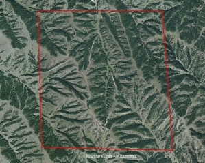
This ranch is beautiful! There is lots of trail development throughout the ranch. Two windmills for water. When I was taking pictures, I bumped a cow elk and he calf. There are lots of wild turkey and mule deer on the ranch. The ranch is very secluded and private. There has been very little grazing over the past 2 years. That is why there is so much game.

For More Information
308-532-9300
info@lashleyland.com


For More information on this listing click here:  http://www.lashleyland.com/realestate/cedarridge_ranch.html


View other Nebraska hunting properties from Lashley Land: www.lashleyland.com

This property is also listed on the exclusive Cabela’s Trophy Properties website.


[caption id="attachment_2402" align="aligncenter" width="300" caption="Aerial map of "Cedar Ridge Ranch" for sale in Lincoln County, Nebraska"]Aerial map of "Cedar Ridge Ranch" for sale in Lincoln County, Nebraska[/caption]

Mike Lashley and Lashley Land & Recreational Brokers – A Real Estate Service Like No Other!

Nebraska Farm and Ranch Land For Sale – Cabela’s Trophy Properties


Nebraska River Land For Sale – Waterfowl, Deer and Turkey Hunting

All aerial, topography and location maps provided by The Mapping Network: www.TheMappingNetwork.com

A Nationwide Network of GPS Mapping Professionals
 
Need a Large Wall Map for your property or hunting area? The Mapping Network provides a low cost mapping product for the outdoor enthusiast!  Just let us know what area you want and we will print and ship a beautiful full-color wall map using the best aerial imagery available.

Create your own Aerial Maps here: Make My Own Map


The Mapping Network is proud to announce their firm has been chosen by Cabela’s, the World’s Foremost Outfitter, as a Landowner Services provider for Cabela’s Trophy Properties throughout the United States.  Visit us on the Cabela’s Trophy Properties website >> click here