Friday, October 30, 2009

Nebraska River Land with Cabin. Hunt Whitetail Deer and Turkey on this Property near Omaha

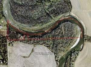
Premier Outdoor Properties has a new  hunting property along the Elkhorn River for sale.
Here's your chance to own that perfect "cabin on the river" you have been dreaming about!
  • A great opportunity to hunt white-tailed deer and turkey on the Elkhorn River bottom with close proximity to the Omaha Metro area.
  • The spacious cabin features plenty of room for family and guests to entertain, or just relax.  The seller has installed a new roof, furnace, central air, and appliances in 2007.
  • The winding river bottom features plenty of trees that provide excellent wildlife habitat and walking trails, as well as outstanding morrell mushroom hunting in the Spring.
  • Enjoy waterfowl hunting on the east side of the property where the waters are calmer and provide easy access for the ducks and geese to drop in.
  • Entertain family and friends on the sandy beaches along side the beautiful Elkhorn River.  Bring your canoes and travel downstream to your favorite destination.
For More information on this listing click here:  http://www.premieroutdoorproperties.com/viewlisting.php?returnstate=NE&listingid=157

View other Nebraska hunting properties from Lashley Land:  www.premieroutdoorproperties.com


Nebraska River Land with Cabin.  Hunt Whitetail Deer and Turkey on this Property near OmahaNebraska River Land with Cabin. Hunt Whitetail Deer and Turkey on this Property near Omaha

The Mapping Network:  www.TheMappingNetwork.com
A Nationwide Network of GPS Mapping Professionals

Thursday, October 29, 2009

Nebraska Hunting and Fishing Land For Sale

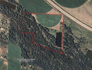
Lashley Land has a new  hunting and fishing property for sale. Here is the place you have been looking for close to North Platte, NE.  Thick stands of timber, a 10 acre lake stocked with crappie, white bass, catfish, walleye, bluegill, perch and largemouth bass.  The property has a 2 bedroom, 1 bath home, garage and outbuildings.  There are two permanent deer stands (one is big enough for 4 people and a card table!).  This property has been managed and kept for deer hunting and has been owned by the same family for 13 years.  This end of the road destination will make a great family hunting and recreational property.
 
For More information on this listing click here: http://www.lashleyland.com/realestate/trails_end.html

View other Nebraska hunting properties from Lashley Land:  www.lashleyland.com

Nebraska Land For Sale: Fishing, Waterfowl, Deer and Turkey Hunting Nebraska Land For Sale: Fishing, Waterfowl, Deer and Turkey Hunting
The Mapping Network:  www.TheMappingNetwork.com
A Nationwide Network of GPS Mapping Professionals

Monday, October 26, 2009

Lake Mapping to Monitor Sedimentation Levels

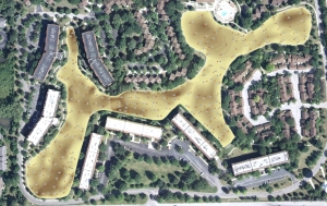
Integrated Lakes Management recently completed a Bathymetric Lake Mapping project for a lake association in DuPage County, Illinois.   In addition to the bathymetric survey,  sedimentation depths were collected and a model of sedimentation levels was created to estimate the volume of sludge in the lake.  The resulting map provided the baseline depth profile needed for long-term sedimentation monitoring and dredging plans.

Color-Shaded Depth Lake Map Color-Shaded Depth Lake Map

Sediment Depth Points with Color-shaded sludge thicknessSediment Depth Points with Color-shaded sludge thickness
More information on Integrated Lakes Management visit their website:  www.lakesmanagement.com

The Mapping Network:  www.TheMappingNetwork.com
A Nationwide Network of GPS Mapping Professionals

Public Lake Mapped in Denver Metro

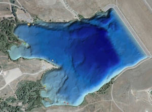
A popular recreation area in Lakewood, Colorado was recently mapped by Absolute Natural Resources, LLC.  The resulting bathymetric lake map will assist management decisions of Bear Creek Lake by understanding the topography of the bottom of the reservoir.  The public will also enjoy the benefits of a new, accurate lake map by easily identifying areas to fish.

More information on Absolute Natural Resources, LLC can be found on their website:  www.anrwildlife.com

Color Shaded Bathymetric Lake Map of Bear Creek LakeColor Shaded Bathymetric Lake Map of Bear Creek Lake
The Mapping Network:  www.TheMappingNetwork.com
A Nationwide Network of GPS Mapping Professionals

Wednesday, October 14, 2009

Lake Map Helps Owner Locate Fish Hot Spots

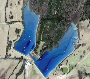
Southeastern Pond Management  recently completed a lake mapping project for a client in Mississippi.  The primary reason for mapping the pond was to assist the owner in locating the best areas to fish.  This information will be conveyed to all clients visiting the lake so they will spend less time searching and more time reeling in largemouth bass.  Existing structure and feeders were mapped and numbered with GPS coordinates for easy locating while on the boat.  Also, areas of excavation and old creek channels are easily identified.

As far as a management tool, Southeastern Pond Management uses the lake map to get exact acres for stocking, help calculate how many weeds may be present, calculate acre/feet for treatments such as rotenone applications.  In other words, provide the client with the best fishing possible from his pond.
More information on Southeastern Pond Management can be found on their website:  www.sepond.com

Color Shaded 3D Lake Map with Structure and Feeders

The Mapping Network:  www.TheMappingNetwork.com
A Nationwide Network of GPS Mapping Professionals

Tuesday, October 6, 2009

US Army Corps of Engineers Lake Mapping Project

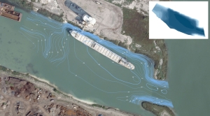
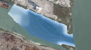
The US Army Corps of Engineers teamed up with Integrated Lakes Management for a Bathymetric Lake Mapping project in Chicago.  Ships and barges using this particular harbor have been battling sedimentation while navigating through the water  and required a bathymetric survey to understand the severity of the problem.   GPS lake mapping techniques developed by The Mapping Network were used to create an accurate depth model of the harbor.

Bathymetric Contour Map
Bathymetric Contour Map 

A color shaded depth map with bathymetric contour lines

More information on Integrated Lakes Management visit their website:  www.lakesmanagement.com

The Mapping Network:  www.TheMappingNetwork.com
A Nationwide Network of GPS Mapping Professionals
Monday, October 5, 2009

Lake Mapping: Is it for me?

To fully enjoy your lake or pond it is essential to know the facts: exact acreage, depths, and chemistry of your lake to make the best management decisions including placement of structure, stocking densities, fish species selection, weed control, where those bass may well be hiding, etc. The Mapping Network maps lakes throughout the entire year but typically the best time to map a lake is from fall until spring, while the weeds are down. An accurate lake map provides the information needed to make the most of your aquatic resource. The Mapping Network provides the highest quality and is the most affordable bathymetric mapping system on the market today. If you are serious about maintaining a high-quality lake or pond, be sure you have the ability to make the best decisions, get your lake mapped by the professionals at The Mapping Network.

Give us a call, send an e-mail or visit our website to find out more details.
phone: (402)241-8177
e-mail: info@themappingnetwork.com
web:  www.themappingnetwork.com

Friday, October 2, 2009

Pond Medics, Inc Uses Lake Mapping Technology To Save Homeowner Association 50% From Original Dredging Bids

For lake associations or landowners undertaking a significant lake or pond renovation project, having an accurate map is essential for effective sediment removal.  Dredging companies and their clients benefit from knowing where and how much sediment needs to be removed to achieve the desired results.  This knowledge is made clear by having the lake professionally mapped.  Trent Lewis with Pond Medics, Inc. (Prosper, TX) put this technology to use for a client, in this case a lake association in Dallas, Texas.  The board of directors had a cove on the lake which had filled in with so much sediment that homeowners were unable to launch their boats.  The association wanted to achieve a minimum depth of three feet to allow boats to travel through without worry.  Originally bids were acquired by three contractors but the association became confused when the bids ranged from $170,000 to $210,000 for sediment removal.  Mr. Lewis suggested a solution where the lake would be mapped and sediment measurements taken to create a comprehensive base map for the dredging companies to hone their bids.  The result allowed the board of directors the ability to fine-tune the bids and the entire project was completed for $92,000.  The lake was then re-mapped upon completion of the dredging to verify sediment had been removed.  Mr. Lewis said the board was extremely thankful for having the ability to accurately map their lake and as a result the association was able to save nearly 50% off the original cost for the dredging project.

Benefits to Association
  • Locate and identify areas to be dredged
  • Save time and money by providing contractors with accurate plan
  • Peace of mind knowing all work is completed to plan
  • Ability to monitor sediment over time with routine mapping
Benefits to Dredging Company
  • Understand the scope of work
  • Accurately bid projects with better information
  • Provide the client with a map to prove work is completed
For more information on Pond Medics, Inc. visit their website: www.pondmedics.com
The Mapping Network:  www.TheMappingNetwork.com 

A Nationwide Network of GPS Mapping Professionals
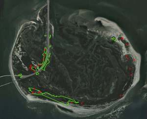
GPS Mapping to Successfully Treat Phragmites

Virginia Lake Management Company is a certified aquatic pesticide applicator in Virginia, Maryland, North Carolina, West Virginia, Delaware, and Pennsylvania, and as such, was contracted by the US Fish and Wildlife Service in a partnership with helicopter applicators to provide the ground application resources required to treat the areas of Phragmites growth that was not able to be treated through aerial applications.  As a certified mapping partner of The Mapping Network, Virginia Lake Management used GPS mapping technologies to document and provide detailed maps and aerial photography of the areas in which the Phragmites were treated
.
Not only did this allow the customer to quantify the acreage of areas treated and evaluate the costs of the project, it also allowed them to track the progress of the program as compared to previous years.  This was the second year that Virginia Lake Management was involved in this project, and progress can already be seen. The density of the Phragmites after the first year’s treatment has been decreased, and much of the natural vegetation has started to recover and return to the areas that were once dominated by Phragmites.

Phragmites is known for its durability and extremely aggressive patterns of growth so this will be an ongoing effort that will likely take many years.  However, with the right treatment, and the proper tools and use of GPS technology and aerial imagery, we are able to make great strides towards our goals of eradication of the Phragmites and the restoration of this beautiful natural habitat.

More information on Virginia Lake Management can be found on their website:  www.virginialakemanagement.com

Locating and treating Phragmites using GPS / GIS mappingLocating and treating Phragmites using GPS / GIS mapping
The Mapping Network:  www.TheMappingNetwork.com

A Nationwide Network of GPS Mapping Professionals