Friday, November 13, 2009

Nebraska Hunting Land For Sale

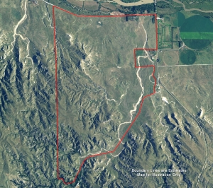
Over 2,000 Acres of Rough Canyon Mule Deer Country
This ranch has some of the roughest canyons we've seen. Excellent mule deer habitat. Lots of tree cover and great access to the land. There is also an abundance of wild turkey in these hills. There is a historic rock call "Flat Top Rock" that is elevated 300' to 400' above the Platte River Valley. Tremendous refuge. Hundreds of thousands of waterfowl winter on this refuge. This property could easily be improved to include waterfowl hunting. This is priced reasonable and has excellent potential

For More information on this listing click here:  http://www.lashleyland.com/realestate/mulie_buttes.html

View other Nebraska hunting properties from Lashley Land:  www.lashleyland.com

Click her for Aerial Map (pdf):  Mulie Buttes Ranch Aerial


Nebraska Hunting Land For SaleNebraska Hunting Land For Sale

The Mapping Network:  www.TheMappingNetwork.com
A Nationwide Network of GPS Mapping Professionals

Tuesday, November 10, 2009

Contour Lake Map in Google Earth

The Mapping Network is proud to announce our custom lake mapping products can be fully integrated into Google Earth.   Simply add the contour KML file to Google Earth and take control by flying around or zooming in and out of the area.

Lake Contour KML file: http://sites.google.com/site/themappingnetworkkml/kml/Lake.kml

Need Google Earth?  Download it here:  http://earth.google.com/


Contour Lake Map in Google EarthContour Lake Map in Google Earth 
 
The Mapping Network:  www.TheMappingNetwork.com 
A Nationwide Network of GPS Mapping Professionals
Thursday, November 5, 2009

Lake Mapping Assists in Successful Lake Management

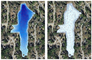
Successful lake management requires an understanding of composition, depth and volume of your lake.  Greg Grimes, President of Aquatic  Environmental  Services, Inc (Ball Ground, Georgia), had a client request an updated lake map to note current depths and mark sediment depths.  Information gathered during the lake mapping process helped Mr. Grimes’ client better comprehend the level of sedimentation building up over time in this fishing lake.  The resulting map provided the baseline depth profile needed for long-term sedimentation monitoring.  Plus, the property owners had several large format wall maps printed to show friends and family where to catch the big ones!

More information on Aquatic Environmental Services, Inc visit their website:  www.lakework.com


Bathymetric Lake Map
Bathymetric Lake Map: 3D Color-shaded depths and contour map with locations of sediment measurements


The Mapping Network:  www.TheMappingNetwork.com
A Nationwide Network of GPS Mapping Professionals

Wednesday, November 4, 2009

Kansas Hunting Land For Sale

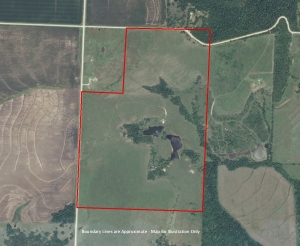
Kansas pasture land and two ponds for sale  -  listed by Kansas Land Brokers
Awesome views! Perfect recreational property with two stocked ponds. Concrete pad with power. Perfect setup for weekend getaway for hunting, fishing and enjoying the peace and quiet. Pasture land all fenced with some timber in creek bed.

For More information on this listing click here:  http://www.postlets.com/res/2869912
View other Kansas hunting properties from Kansas Land Brokers:  http://kansaslandbrokers.com/


Kansas Hunting Land with Ponds For Sale - 185 acresKansas Hunting Land with Ponds For Sale - 185 acres


The Mapping Network:  www.TheMappingNetwork.com
A Nationwide Network of GPS Mapping Professionals
Tuesday, November 3, 2009

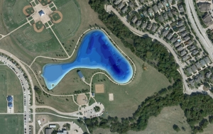
3D Bathymetric Lake Map of City Park near Dallas, Texas

Pond Medics recently completed a Bathymetric Lake Mapping project for a city just north of Dallas.  The purpose of this project involved sediment monitoring for future dredging.  The mapping techniques utilized in this project allows Pond Medics to accurately isolate areas of high sedimentation for removal and help city administrators budget accordingly.  The critical information produced by GPS bathymetric mapping allows for smart management decisions and will save the city thousands of dollars in the future.

3D Bathymetric Lake Map
3D Bathymetric Lake Map of City Park near Dallas, Texas

More information on Pond Medics visit their website:  www.pondmedics.com

The Mapping Network:  www.TheMappingNetwork.com
A Nationwide Network of GPS Mapping Professionals