Thursday, February 25, 2010

Lake Mapping Partner Shares Knowledge on YouTube

Lake Mapping Partner Shares Knowledge on YouTube

Lake Map Video on YouTube

Greg Grimes with Aquatic Environmental Services, Inc., shares his lake management expertise in a series of short videos on YouTube.  Aquatic Environmental Services, Inc offers a wide range of lake management, GPS lake mapping and fisheries management services to residential, commercial, and private lake owners throughout Georgia and the southeast.

Click for YouTube Video on Fish Stocking
Click for YouTube Video on Electrofishing Survey
Click for YouTube Video on Fish Feeding
Click for YouTube Video on Fish Tagging

More information on Aquatic Environmental Services, Inc can be found on their website:  http://lakework.com

The Mapping Network:  www.TheMappingNetwork.com
A Nationwide Network of GPS Mapping Professionals

GPS Lake Map

GPS Lake Mapping

GPS Bathymetric Lake Map

Tuesday, February 23, 2010

Understanding GPS Lake Mapping

When Accuracy Matters: GPS Lake Mapping

GPS Bathymetric Lake Mapping by The Mapping Network

On the surface, a lake or pond seems serene and effortless to maintain, but under the shell is a complex, dynamic organism requiring expert knowledge to produce a perfect balance.  To fully enjoy your lake or pond it is essential to know the facts.  Exact acreage, depths, and chemistry of your lake are critical factors for making the best management decisions.  Armed with this knowledge you will be able to properly place structure, deliver appropriate stocking densities, select the correct fish species, apply the right amount of weed control, and of course gain a better idea where those bass may be hiding!  The Mapping Network maps lakes throughout the entire year but typically the best time to map a lake is from fall until spring, while the weeds are down.  An accurate lake map provides the information needed to make the most of your aquatic resource.   The Mapping Network provides the highest quality and is the most affordable bathymetric mapping system on the market today.  If you are serious about maintaining  a high-quality lake or pond, be sure you have the ability to make the best decisions,  get your lake mapped by the professionals at The Mapping Network.   Give us a call or send an e-mail to find out more details.

phone:  (402) 241-8177

e-mail: info@themappingnetwork.com

website: www.themappingnetwork.com

The attention to detail makes our GPS Lake Maps a valuable tool for successful management
The Mapping Network:  www.TheMappingNetwork.com A Nationwide Network of GPS Mapping Professionals

Friday, February 19, 2010

Lake Mapping to Maximize Management Plans

GPS Lake Mapping

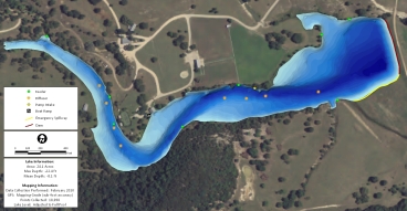
Pond Medics Inc., successfully completed a GPS lake mapping project for a client in central Texas.  The owner of the lake wanted an accurate, up-to-date base map highlighting the old creek channel and marking existing diffusers and feeders with GPS coordinates.  This new lake map will assist the owner in locating the most favorable areas to fish.  As far as a management tool, Pond Medics will use the lake map to calculate acres for stocking, help evaluate how many weeds may be present, calculate acre/feet for treatments, etc.  In other words, provide the client with the best fishing possible on his lake.

Color-shaded 3D Depth Map of a Lake in Texas

More information on Pond Medics can be found on their website:  www.pondmedics.com

The Mapping Network:  www.TheMappingNetwork.com

A Nationwide Network of GPS Mapping Professionals

Thursday, February 11, 2010

GPS Lake Map Isolates Fishing Hot Spots

Possessing an accurate map of your lake is a great asset to your fishing success.  Greg Grimes with Aquatic Environmental Services, Inc., recently completed a GPS lake mapping project for a client in Georgia.  This is a master planned lake designed specifically for growing trophy large-mouth bass.  Extensive habitat structure, ridges, brush, feeders, etc were carefully placed during construction.  Once the lake was full the client had the lake mapped utilizing The Mapping Network’s lake mapping technology to reveal this unseen, underwater world.  Combining sub-foot accurate equipment and depth accuracies of up to 1/10th of a foot, the resulting maps provided a  picture of the bottom of the lake.  Mr. Grimes was able to provide a map highlighting the ideal fishing zones in the range of 4 feet to 16 feet deep at 1 foot intervals.  This lake map shows the angler exactly where the fishing hot spots are located on the lake.  If you are serious about managing a trophy fishery in your lake contact one of our lake mapping partners to provide the expertise to make it happen!

GPS Lake Map Isolates Fishing Hot Spots
Custom GPS Lake Map Helps Isolate Fishing Hot Spots in the 4 ft to 16 ft range. 

More information on Aquatic Environmental Services, Inc can be found on their website:  http://lakework.com

The Mapping Network:  www.TheMappingNetwork.com

A Nationwide Network of GPS Mapping Professionals

Spectacular Nebraska Land For Sale: Niobrara River Frontage with Excellent Hunting Opportunities

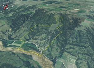
Nebraska Hunting Land For Sale - This Is One Amazing Piece of Nebraska Real Estate. 3/4 Mile of Niobrara River Frontage and Over 1 Mile of Lucky Creek Running Through the Ranch.
You will have to look long and hard to find a ranch like this one.  Niobrara River frontage, live creek water, secluded alfalfa fields and tremendous rugged canyon land that is 80% tree covered.  There are White-tailed Deer, Mule Deer, Merriams Wild Turkey all in abundance.

The ranch borders the Thomas Creek Wildlife Management Area.  This is over 1,000 acres of Public Land that is walk-in only hunting.  This makes it extremely hard for the Public to get to the back side.  It’s like having an extra 1,000 + acres to hunt.  What makes this one of the finest deer hunting spots is the 89 acres of alfalfa.  These fields are surrounded by tremendous bedding cover.  It’s a huge food plot that is miles from the nearest road.  I drove my Polaris Ranger within 40 yards of 4 White-tailed Deer.  They rarely see people.  There is a cozy 4 bedroom, 3 bath house with garage and a good metal building included.  The current owner would stay on as a tenant and caretaker.  More road development could be made to improve the ranch.  The current owner has the equipment and know how to do both.

For More information on this listing click here:  http://www.lashleyland.com/realestate/luckycreek_ranch.html

View other Nebraska hunting properties from Lashley Land: www.lashleyland.com
View Property Virtual Fly-Over on You Tube:  Click for Virtual Tour
Click her for Aerial Map (pdf): Aerial Map of Nebraska Hunting Land For Sale


Nebraska Hunting Land For Sale - This Is One Spectacular Piece of Nebraska Real Estate. 3/4 Mile of Niobrara River Frontage and Over 1 Mile of Lucky Creek Running Through the Ranch. Nebraska River Land For Sale – Waterfowl, Deer and Turkey Hunting

The Mapping Network: www.TheMappingNetwork.com A Nationwide Network of GPS Mapping Professionals

Nebraska Hunting Land For Sale – This Is One Spectacular Piece of Nebraska Real Estate. 3/4 Mile of Niobrara River Frontage and Over 1 Mile of Lucky Creek Running Through the Ranch.
Nebraska River Land For Sale – Waterfowl, Deer and Turkey Hunting

GPS Mapping Urban Ponds for Dredging

A case study of Lakeside on Preston HOA in Plano, TX by Trent Lewis with Pond Medics, Inc. is featured in a North Texas Homeowners Association publication.

The Mapping Network is instrumental in bringing GPS lake mapping technology to the recreational market.  Their experience wit the most efficient GPS and sonar technology allows their partners, like us, to offer these unique services to our clients.  Pond Medics utilizes this lake mapping technology to reveal this unseen, underwater world.  Combining sub-foot accurate equipment and depth accuracies of up to 1/10th of a foot, we can produce a picture of what few people will ever see – the bottom of your lake.

Click here for GPS Lake Mapping Article

3D map of post-dredged lake

More information on Pond Medics can be found on their website:  www.pondmedics.com

The Mapping Network:  www.TheMappingNetwork.com

A Nationwide Network of GPS Mapping Professionals

GPS Lake Mapping Verifies Dregding Project

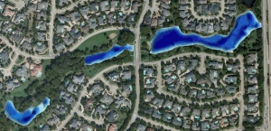
3D GPS Bathymetric Lake Mapping validates Dredging Project
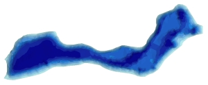
Trent Lewis with Pond Medics, Inc. provided an Arlington, Texas Home Owner Association the validation of knowing a dredging project went as planned.  Pond Medics, a lake mapping partner with The Mapping Network, charted the bottom of the lake before and after the dredging project to monitor the improvements.  Not only was the HOA able to verify the work had been completed properly, they now have a basemap to monitor sediment accumulation over time.  GPS bathymetric mapping is a powerful tool for assisting in management decisions.
GPS Bathymetric Lake Map
GPS Lake Map of Texas Homeowners Association after dredging was completed

More information on Pond Medics can be found on their website:  www.pondmedics.com

The Mapping Network:  www.TheMappingNetwork.com

A Nationwide Network of GPS Mapping Professionals

GPS Maps of Hunting Land and Lakes – Improve Property Management

Absolute Natural Resources provides extensive land and habitat GPS mapping services involving the use of complex data collection methods, state of the art GIS and GPS technology and satellite imagery.  Absolute Natural Resources offers a variety of mapping services and products for real estate professionals, private landowners, fishing and hunting clubs, habitat and lake developers, hunting lease managers, timber management firms, and recreational land companies.  Located in Denver, Colorado, Absolute Natural Resources has the experience to handle mapping projects in the steep terrain of the Rocky Mountains to the gentle hills of the Great Plains region.  Common client requests include, but are not limited to, aquatic vegetation beds, wetlands, streams, irrigation canals, inlet and outlet features, dam facilities, habitat structures, boat ramps, fishing piers, duck blinds, waterfowl nests and site-specific channels.
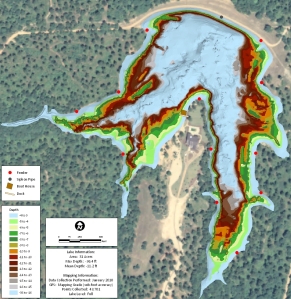
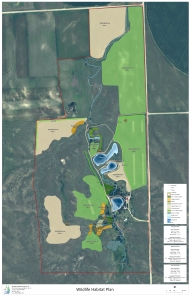
A recent project for a client included creating a detailed Nebraska habitat plan to allow the land owner to visualize and study the feasibility of constructing a world-class hunting and fishing destination.  Mapping the three lakes on the property allows proper management of largemouth bass by knowing exact depths and acreage for stocking densities and vegetation control.  The maps are a handy tool for guests to the ranch by showing all trails and fishing hot spots.

More information on Absolute Natural Resources, LLC can be found on their website:  www.anrwildlife.com

GPS Habitat Map
GPS Habitat and Lake Map
The Mapping Network:  www.TheMappingNetwork.com

A Nationwide Network of GPS Mapping Professionals

Outstanding Nebraska Recreational Property For Sale

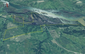
Premier Outdoor Properties has a new  hunting property along the Missouri River at the Mouth of the Niobrara River for sale.
This is your opportunity to own a historical parcel of land that stretches to the mouth of the Niobrara River close to where Lewis and Clark camped many years ago.
  • Rolling timbered hills overlooking the sandy Missouri River provide breathtaking views that are unmatched in the state of Nebraska.
  • The property has 2+/- miles of Missouri River Frontage that extends to the mouth of the Niobrara River
  • There are several lakes and ponds scattered throughout the hills that provide an excellent setting for building opportunities such as cabins or a private resort lodge.
  • The combination of bluff ground and Missouri River frontage provides an abundance of wildlife to hunt or fish.
  • This property is a recreational playground!  You can hunt whitetail and mule deer, turkey, pheasants, duck, geese, quail, and bobcats.
  • This area provides some of the best fishing in the State of Nebraska.  Anglers from all around enjoy fishing for walleye, northern pike, smallmouth bass,  largemouth bass, and sauger.
  • The property features a rustic hunting cabin-lodge on the banks of the Missouri River that can sleep 9 guests.  The lodge is located near permanent and floating duck blinds for guests to enjoy the outstanding waterfowl season.
  • The lodge is equipped with all the cooking appliances necessary to feed hungry guests after a successful day of fishing or hunting.
  • Ride your ATV or hike for miles in the hills and experience one of the most beautiful places in the country.
For More information on this listing click here:  http://www.premieroutdoorproperties.com/viewlisting.php?returnstate=NE&listingid=170

View other Nebraska hunting properties from Premier Outdoor Properties:  www.premieroutdoorproperties.com


View Property Virtual Fly-Over on You Tube:  Click for Virtual Tour 
 
Premier Outdoor Properties has a new  hunting property along the Missouri River at the Mouth of the Niobrara River for sale.
Premier Outdoor Properties has a new hunting property along the Missouri River at the Mouth of the Niobrara River for sale.

All maps and virtual fly-over provided by The Mapping Network:  www.TheMappingNetwork.com
A Nationwide Network of GPS Mapping Professionals

Nebraska River Land For Sale – Waterfowl, Deer and Turkey Hunting

Nebraska Hunting Land For Sale - A Great Little Spot to Hunt Deer and Wild Turkey
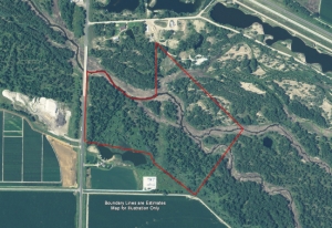
This riverbottom accretion is full of white-tailed deer beds.  Also it includes both sides of the river.  It could be excellent waterfowl hunting as well.  Quail and wild turkey in the spring would be a great bonus as well.  Close to town, but very secluded.  This area has a history of huge whitetail harvests.  This land is adjacent to irrigated corn, beans and alfalfa.  This is where the deer bed down.

For More information on this listing click here:  http://www.lashleyland.com/realestate/pony_express.html

View other Nebraska hunting properties from Lashley Land: www.lashleyland.com

Click her for Aerial Map (pdf): Aerial Map of Nebraska Hunting Land For Sale

Nebraska River Land For Sale – Waterfowl, Deer and Turkey Hunting

The Mapping Network: www.TheMappingNetwork.com A Nationwide Network of GPS Mapping Professionals

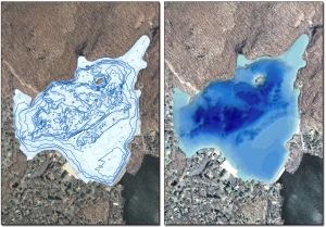
GPS Bathymetric Lake Mapping in New Jersey

GPS Bathymetric Lake Mapping was performed by Allied Biological for a 60 acre lake in northern New Jersey.  The lake association had questions regarding true depth of the expansive, undulating body of water.  After completion of a new bathymetric map by Allied Biological and The Mapping Network, the lake association now has a detailed map of the contours of the lake bottom, providing an outstanding tool for fishermen, and a valuable resource for management of the lake’s plant and algae communities.
More information on Allied Biological visit their website:  www.alliedbiological.com

lake mapping
GPS Bathymetric Lake Mapping

The Mapping Network:  www.TheMappingNetwork.com
A Nationwide Network of GPS Mapping Professionals

Nebraska Hunting Land for Sale

Nebraska Hunting Land For Sale – A great ranch home on 9 acres of land
This home is less than 5 minutes from Swanson Reservoir just West of Trenton, Nebraska.  This exceptional property is meticulously maintained and well developed.  This ranch style 2,600 sq. ft. home has a full walk-out basement & plenty of storage, perfect for entertaining your guests.  4,600 acres of wildlife management areas are virtually at your door step, not to mention the deer & turkey that exist on the property’s 9 acres.  Other amenities include a 4,000 sq. ft. metal barn with an enclosed large office, oil pit & generator as well as 2 outbuildings for storage, dog lodging and runs & a gun site shooting range in the canyon area.  Treat yourself to this great recreational property today.

For More information on this listing click here:  http://www.lashleyland.com/realestate/whispering_pines.html
 
View other Nebraska hunting properties from Lashley Land:  www.lashleyland.com
Click her for Aerial Map (pdf):  Whispering Pines Estate


Nebraska Land For Sale
Hitchcock  County Nebraska  Land For Sale

The Mapping Network:  www.TheMappingNetwork.com
A Nationwide Network of GPS Mapping Professionals