Thursday, April 29, 2010

GPS Lake Map Guides Lake Management Plan

GPS Lake Map Guides Lake Management Plan

GPS Bathymetric Lake Mapping by The Mapping Network

On the surface, a lake or pond seems serene and effortless to maintain, but under the shell is a complex, dynamic organism requiring expert knowledge to produce a perfect balance.  To fully enjoy your lake or pond it is essential to know the facts.  Exact acreage, depths, and chemistry of your lake are critical factors for making the best management decisions.  Armed with this knowledge you will be able to properly place structure, deliver appropriate stocking densities, select the correct fish species, apply the right amount of weed control, and of course gain a better idea where those bass may be hiding!  The Mapping Network maps lakes throughout the entire year but typically the best time to map a lake is from fall until spring, while the weeds are down.  An accurate lake map provides the information needed to make the most of your aquatic resource.   The Mapping Network provides the highest quality and is the most affordable bathymetric mapping system on the market today.  If you are serious about maintaining  a high-quality lake or pond, be sure you have the ability to make the best decisions,  get your lake mapped by the professionals at The Mapping Network.   Give us a call or send an e-mail to find out more details.
phone:  (402) 241-8177
e-mail: info@themappingnetwork.com
website: www.themappingnetwork.com

Powerful, Proven Results:

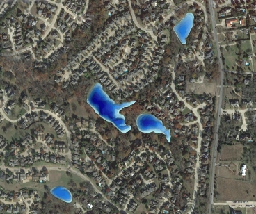
Bathymetric Lake Mapping was performed by Trent Lewis with Pond Medics, Inc., for a homeowners association in a suburb northeast of Dallas, Texas.  The purpose of this project was to create a base map of lake depths and locate areas of sediment accumulation.  The mapping techniques utilized in this project and subsequent lake mapping results allowed Pond Medics to devise an accurate resource management plan for the association.

Mr. Lewis says to “think of your lake map as a window into an unseen world. The lake map can be used to track changes in this dynamic environment. Use it as a planning and budgeting tool in your community. The sooner a lake is mapped, the more informed your lake management decisions will be.”

The finished project included a Bathymetric Lake Map with 3D Color-shaded depths and contour map with locations of high risk sediment areas.

3D Lake Map
3D Color-Shaded Depth Map of a Series of Lakes
For more information on Pond Medics, Inc. please contact:
Trent Lewis
phone: (972) 334-0104
e-mail:  info@pondmedics.com
website:  www.pondmedics.com
The Mapping Network:  www.TheMappingNetwork.com
A Nationwide Network of GPS Mapping Professionals

GPS Lake Map

GPS Bathymetric Lake Map

Tuesday, April 27, 2010

Nebraska Land For Sale: Mallard Hallows Farm

Nebraska Land For Sale on The South Platte River

A Great Productive Farm That Can Be Developed for Even More Production.
This farm is adjacent to the South Platte River.  You could realize an additional $3,000 to $5,000 cash lease for hunting rights.  Habitat development would also increase the value of this land.  You have the advantage of additional appreciation with both ag land values and recreation values.  This along with the cash rent potential makes this a solid investment.  There is currently 60 acres of pivot irrigated crop on this farm.  Farm Service Agency has certified that at total of 136 acres could be irrigated.  The C.R.P. Program portion of this farm comes out of the C.R.P. Program September 30, 2010.   There can be an additional 76 acres of pivot development that could be added.  The existing well pumps over 1,400 gallons per minute.  That means that this well would have the capacity to run both pivots at the same time.  The remaining acres could be farmed or put back into C.R.P. if the Government Programs would allow.  Also all of the crop land is currently or could be certified for organic farming.  The 60 acre pivot is currently being farmed organic.

For More information on this listing click here:  http://www.lashleyland.com/realestate/mallard_hallows_farm.html

View other Nebraska hunting properties from Lashley Land: www.lashleyland.com


Aerial Map showing the possibilities of this outstanding recreational property on the South Platte River in Nebraska


Mike Lashley and Lashley Land & Recreational Brokers – A Real Estate Service Like No Other!
Mike Lashley of Lashley Land and Recreational Brokers has over Thirty Five Years of real estate brokerage experience. He has deep roots in the West Central Area of Nebraska. An avid hunter, fisherman and guide!   Lashley Land & Recreational Brokers, Inc., has joined forces with Cabela’s Trophy Properties, Inc., multiple listing site to provide the best possible service to its seller clients.  Cabela’s Trophy Properties, Inc. has developed a multiple listing service through its web page, www.cabelas.com for brokers with exceptional recreational hunting lands for sale.

What kind of expertise do you get which Lashley Land and Recreational Brokers?  A Broker that specializes in hunting land. Mike Lashley has hunted upland game, waterfowl, and big game avidly for 40 years. He knows what a hunter wants and expects. A Broker that can provide the hunter with a professional full service outfitter. Fully guided hunts for all of the mixed bag available in Nebraska. A Broker that can arrange either trespass fees for day hunts, or season hunting leases. He knows where the best hunting lands are and knows who owns them. He can put the landowner and the hunter together professionally. A Broker that is a consultant to the landowner for the development of wildlife habitat. A Broker that is an expert in finding government programs to pay the landowner for developing wildlife habitats.  A Broker that also serves as a farm manager. He knows who the most reliable farmers are to provide the owner with income and good land stewardship

Nebraska Farm and Ranch Land For Sale

Nebraska River Land For Sale – Waterfowl, Deer and Turkey Hunting

All maps provided by The Mapping Network:  www.TheMappingNetwork.com

The Mapping Network: www.TheMappingNetwork.com A Nationwide Network of GPS Mapping
Professionals
Need a Hunting Map for a small price? The Mapping Network and MyTopo have teamed up to provide a low cost mapping product for the outdoor enthusiast!

Create your own Aerial and Topo Maps here: Make My Own Map

Friday, April 23, 2010

Engineers use GPS Lake Map to Plan for Dredging Project

Engineering Company Chooses GPS Lake Mapping Experts

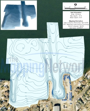
AquaTechnex provided a bathymetric lake mapping survey for a marina on a large lake in California.  Engineers needed to have an accurate, up-to-date lake depth map because they were planning to dredge the immediate area and replace existing infrastructure .  The resulting lake map created by AquaTechnex and The Mapping Network is precisely what the engineers required to complete the new design.

GPS Bathymetric Lake Map created by Aquatechnex and The Mapping 
Network for a marina in California
GPS Bathymetric Lake Map created by Aquatechnex and The Mapping Network for a marina in California

Aquatechnex is a fully integrated lake and aquatic plant management firm that operates primarily in the Western United States and Upper Midwest States.  Our company is a recognized expert in the management of invasive aquatic species such as Eurasian Milfoil, Brazilian Elodea, Hydrilla and Water Hyacinth.  Our company mission is to provide solutions to insure the beneficial uses of our clients water bodies are protected. These solutions will involve the development and implementation of effective programs using integrated lake and aquatic plant management technologies. We will strive to be the best in our field and a company that lake groups will seek out for our expertise to insure our continued growth.

Give us a call or visit our website to find out more information.

Terry McNabb
phone: (208) 338-8490
e-mail:  tmcnabb@aquatechnex.com
website:  www.aquatechnex.com
blog:  http://aquatechnex.wordpress.com/

The Mapping Network:  www.TheMappingNetwork.com
A Nationwide Network of GPS Mapping Professionals

GPS Lake Map

GPS Lake Mapping

GPS Bathymetric Lake Map

Wednesday, April 21, 2010

Cost-Effective Sediment Monitoring with GPS Lake Mapping

GPS Lake Map to Monitor Sediment Levels

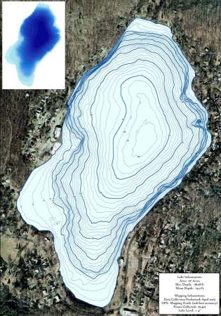
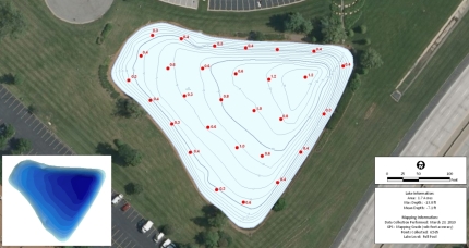
Integrated Lakes Management (ILM) recently completed a mapping project for a Chicago metro property association.  GPS Lake mapping was conducted on site to reveal the actual depths of the water and sedimentation.  The primary purpose of this project involved sediment monitoring for future dredging.  In order to avoid large costs and help property managers budget for sediment removal, ILM located the high priority areas of sediment accumulation and determined the need and location for dredging.  The mapping techniques utilized in this project helps ILM accurately calculate in-situ sediment volume and accumulation over time.  This lake mapping results provided the baseline depth profile needed for ILM to accurately isolate areas of high sedimentation for removal and help property managers budget accordingly.  This powerful information allows for smart management decisions and will save thousands of dollars in the future.  The maps below show how the resulting GPS Lake Mapping Survey helped visualize where the high areas of sedimentation are located.  Please note the maps are compressed and the quality is significantly reduced.  For high resolution examples please contact ILM or The Mapping Network.

Color-shaded lake depths created from bathymetric survey 

Sediment Thickness 3D model created from manual measurements in the field 

More information on Integrated Lakes Management, Inc can be found on their website:  www.lakesmanagement.com

The Mapping Network:  www.TheMappingNetwork.com
A Nationwide Network of GPS Mapping Professionals
GPS Lake Map

GPS Lake Mapping

GPS Bathymetric Lake Map

, , , , , , , , , , , , , , , , , , , , , , , , , , , , ,  

GPS Lake Mapping in Atlanta, Georgia

GPS Lake Map to Monitor Sediment Levels

Greg Grimes with Aquatic Environmental Services, Inc.,  mapped an Atlanta area lake last week.  The small lake (slightly less than 2 acres)  has been suffering symptoms of of significant sedimentation accumulation.  GPS Lake mapping was conducted on site to reveal the actual depths of the water and sedimentation.  A 3D model of sedimentation levels was created to estimate the volume of sludge in the lake.  This information provided the baseline depth profile needed for immediate dredging plans.  The mapping techniques utilized in this project allows Aquatic Environmental Services, Inc to assist the land management company accurately isolate areas of high sedimentation for removal.

Sediment Depth
Lake Map showing sediment depth levels measured last week. This information will be used by the property manager and dredging company to devise the best plan for removal.

More information on Aquatic Environmental Services, Inc can be found on their website:  http://lakework.com

The Mapping Network:  www.TheMappingNetwork.com
A Nationwide Network of GPS Mapping Professionals

GPS Lake Map

GPS Lake Mapping

GPS Bathymetric Lake Map

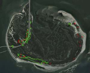
GPS Mapping to Successfully Treat Phragmites

GPS Mapping to Successfully Treat Phragmites

Virginia Lake Management Company is a certified aquatic pesticide applicator in Virginia, Maryland, North Carolina, West Virginia, Delaware, and Pennsylvania, and as such, was contracted by the US Fish and Wildlife Service in a partnership with helicopter applicators to provide the ground application resources required to treat the areas of Phragmites growth that was not able to be treated through aerial applications.  As a certified mapping partner of The Mapping Network, Virginia Lake Management used GPS mapping technologies to document and provide detailed maps and aerial photography of the areas in which the Phragmites were treated.
Not only did this allow the customer to quantify the acreage of areas treated and evaluate the costs of the project, it also allowed them to track the progress of the program as compared to previous years.  This was the second year that Virginia Lake Management was involved in this project, and progress can already be seen. The density of the Phragmites after the first year’s treatment has been decreased, and much of the natural vegetation has started to recover and return to the areas that were once dominated by Phragmites.
Phragmites is known for its durability and extremely aggressive patterns of growth so this will be an ongoing effort that will likely take many years.  However, with the right treatment, and the proper tools and use of GPS technology and aerial imagery, we are able to make great strides towards our goals of eradication of the Phragmites and the restoration of this beautiful natural habitat.

More information on Virginia Lake Management can be found on their website:  www.virginialakemanagement.com

Locating and treating Phragmites using GPS / GIS mapping


The Mapping Network:  www.TheMappingNetwork.com
A Nationwide Network of GPS Mapping Professionals

GPS Lake Map

GPS Bathymetric Lake Mapping

For the best results in mapping, it’s best to consult with a lake management company equipped with the very latest in GPS mapping technology.  Along with standard contour maps, The Mapping Network creates virtual media solutions on YouTube including a fly-over video and virtual underwater virtual swim-through.  With this knowledge, you can add layers of depth to the information you seek to maintain a beautiful lake.

Thursday, April 15, 2010

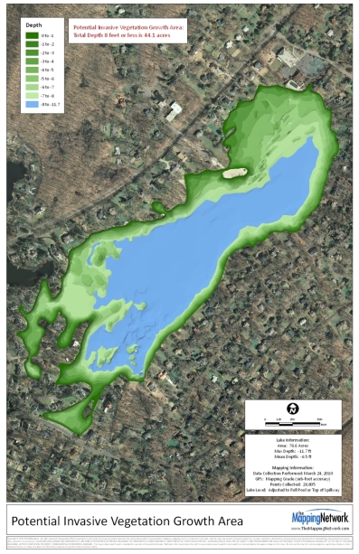
GPS Lake Map Isolates Potential Invasive Vegetation Growth Areas

GPS Lake Mapping Saves Time and Money by Accurately Locating Problem Areas

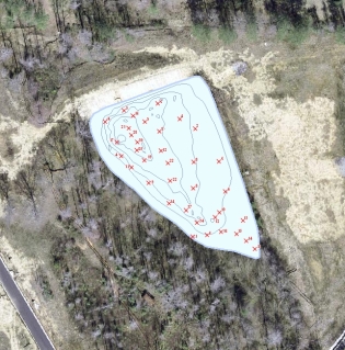
It is critical to know the exact acreage and depth range of your lake to make sound management decisions in the battle against invasive aquatic vegetation.  Understanding exactly where to apply treatment not only saves time and money but more importantly provides a better opportunity to control aggressive, non-native  aquatic plant life.  Precision GPS lake mapping conducted by The Mapping Network utilizes highly accurate procedures and equipment for data collection.  Utilizing sub-foot accurate GPS units and hydro-acoustic depth-sounding equipment, our team logs data points for extremely accurate location mapping.  Hydro-acoustic depth sounding equipment measures depth with unparalleled accuracy.  Our clients are able to accurately isolate zones where invasive vegetation is likely to occur or is currently growing.  Proper management decisions provided by local lake management professionals will assist in controlling or elevation unwanted aquatic vegetation.

A GPS Bathymetric Lake Map and Depth Isolation Survey by The Mapping Network will help optimize your efforts to control invasive aquatic vegetation in your lake or pond.  Please contact us for more information on how this service can assist you in managing your aquatic resource.

Depth Isolation
This map highlights depths up to 8 feet where invasive aquatic vegetation can grow.

The Mapping Network:  www.TheMappingNetwork.com
A Nationwide Network of GPS Mapping Professionals
GPS Lake Map

GPS Bathymetric Lake Map

  Lake Map | Tagged: , , , , , , , , , , , , , , , , , , , | Permalink

GPS Lake Map Assists in Fight Against Invasive Vegetation

GPS Lake Map Assists in Fight Against Invasive Vegetation

Allied Biological and The Mapping Network created a bathymetric lake map to provide a base map for tackling a difficult invasive weed population.  Traditionally lake maps have been used primarily by anglers but it has become an essential tool for lake managers and biologists in establishing lake management programs with regard to herbicide applications, dredging efforts and lake drawdowns.  Bathymetric mapping and subsequent vegetation survey revealed that Mountain Lake contains a diverse plant community including, Eurasian water milfoil (Myriophyllum spicatum), coontail (Ceratophyllum demersum), curly-leaf pondweed (Potamogeton crispus), spatterdock (Nuphar spp.), white water lilies (Nymphaea spp.), bassweed (Potamogeton amplifolius), and watershield (Brasenia schreberi), as well as the branched algae, Chara.  The focus of the 2009 aquatic plant management plan was to control the invasive Eurasian water milfoil in approximately twelve acres of shoreline area.

To continue reading this article click here: GPS Lake Map

Lake Map
Bathymetric Lake Map 

Bob Schindler is an Aquatic Biologist for Allied Biological, providing aquatic habitat management consulting to the northeast region of the country.
Contact Allied Biological:
phone: 908-850-0303
website:  www.alliedbiological.com
 
The Mapping Network:  www.TheMappingNetwork.com
A Nationwide Network of GPS Mapping Professionals

GPS Lake Map

GPS Bathymetric Lake Map

Tuesday, April 13, 2010

Dredging Your Pond – Planning For the Big Dig

by Kimberly Niesel, Virginia Lake Management Company
 
If your community has a lake or pond, it may have crossed your mind that dredging will be needed at some point. Hopefully your community has had a professional reserve study performed which includes funds allocated to a future dredging project.  If you have reviewed this line item, you may see that it is one of the most costly projects that a community will ever undergo. Still, you may find that even though funds have been allocated, these funds may not be adequate to cover the scope of work needed. In order to prepare for the “big dig” that may be around the corner, here are a couple of tips to prolong the time needed between dredging projects:

Bathymetry: Your lake is a dynamic and unique ecosystem. Bathymetry allows you to better understand the changes that are going on in your lake. Bathymetry is the science of three dimensional lake mapping where surface area is shown with the corresponding depths. It shows the underwater mountains and valleys. Specifically it shows the very shallow parts of your pond. It also gives information on the quantity, location, and types of sediments sitting at the bottom of your pond. When compared to original plans, it will also allow you to calculate the rate at which your pond is filling in with sediment. This information allows you to tailor your dredging planning and budgeting to be more site and cost specific, reducing the unknown and taking the guess work out of your long term reserve planning and budgeting.

Aeration: Aeration is an important part to any lake management strategy but specifically it can help prolong the amount of time before dredging is required. The movement of water generated by aeration keeps sediments in a suspended stated not allowing them to settle out and add layers to the bottom of your pond. By adding oxygen and movement to the water, you can slow the accumulation of organic sediment and even help to break down a vast majority of sediments through the microbial processes that are enhanced by the aeration. Minimization of organic sediment accumulation on the bottom of the pond will greatly extend the life of your pond and push back the timeline for dredging.

Fish Stocking (Grass Carp): Fish stocking can be another effective way of increasing time before dredging is required. Stocking your pond with fish, specifically grass carp, is a biological control against nuisance aquatic vegetation and algae. These fish are herbivores and only go after the vegetation in your pond. Removing harmful vegetation improves the “look” of your pond and has the added benefit of removing organic matter that can build up and increase the “filling” of your pond. By consuming these plants the fish are effectively removing any of the nutrients that might be recycled and used for growth of new plants.

Biological Augmentation: Another way to decrease the nutrient build up in your pond is through biological augmentation which is the addition of natural bacteria and enzymes to your pond or lake, also known as “biologicals”. Biologicals are naturally occurring bacteria that utilize excess nutrients in the water for their own growth. This means that they remove the food source that algae and other nuisance vegetation need to grow. These bacteria are also responsible for helping to break down the “organic sludge” sitting on the bottom of your pond. Coupled with aeration, biologicals effectively remove nutrients and break down the organic layer slowing the “filling” of your pond.

Overall there are multiple ways to prolong the time before you need to dredge your pond. These are just a few of the more effective strategies to help your pond from filling up. Through proper pond management you can have a pond that looks great and gives you adequate time to plan for your “big dig.”
For the best results in mapping, it’s best to consult with a lake management company equipped with the very latest in GPS mapping technology.  Along with standard contour maps, VLM and The Mapping Network create virtual media solutions including a fly-over video and virtual underwater virtual swim-through.  With this knowledge, you can add layers of depth to the information you seek to maintain a beautiful lake.

Kimberly Niesel is the Director of Marketing for Virginia Lake Management Company, specializing in pond and lake management.  VLM also controls pond management interests in West Virginia, Pennsylvania, Maryland, Delaware, and North Carolina.
phone: (866) 697-2584
website:  www.virginialakemanagement.com

This pond has less than 2 feet of water and up to 8 feet of sediment accumulation. A bathymetric lake survey was completed to calculate the amount of sediment to be removed. 

The Mapping Network:  www.TheMappingNetwork.com
A Nationwide Network of GPS Mapping Professionals

GPS Lake Map

GPS Bathymetric Lake Map

10,000 acres of Land for Sale in California

10,000 acres of Land for Sale in California

Outstanding California Ranch For Sale in Glenn County, California

This 10,000 +/- acre property is located in Glenn County about 8 miles from Stonyford, CA. Newly renovated 3-story English Tudor home is over 5000 sq ft, 7 bedrooms & 6 baths: Matching 2000 sq ft barn, two ranch homes, barns, outbuildings, water rights to irrigate 150 acres, two year round creeks, over a dozen year round ponds, one estimated to be over 40 acres. Great hunting, hiking and horseback riding.  This is truly a dream property with first class accommodations.  This property is offered by California Outdoor Properties, Participating with Cabela’s Trophy Properties.

For More information on this listing click here:  http://californiaoutdoorproperties.com/viewlisting.php?returnstate=&searchstr=&listingid=348

View other California hunting, ranch or recreational properties from California Outdoor Properties, Participating with Cabela’s Trophy Properties:  www.californiaoutdoorproperties.com

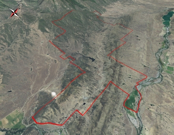
For Aerial, Topography and Location Map click link (pdf):  Big Valley Ranch


This 10,000 +/- acre property is located in Glenn County about 8 
miles from Stonyford, CA. Great hunting, hiking and horseback riding.  
This is truly a dream property with first class accommodations.
This 10,000 +/- acre property is located in Glenn County about 8 miles from Stonyford, CA. Great hunting, hiking and horseback riding. This is truly a dream property with first class accommodations.

All promotional maps for Big Valley Ranch provided by The Mapping Network


The Mapping Network: www.TheMappingNetwork.com A Nationwide Network of GPS Mapping Professionals

Cabela’s Trophy Properties

Wednesday, April 7, 2010

GPS Lake Mapping in St. Louis

Using a GPS Lake Map to Understand Sediment Levels

The Mapping Network and Jim Darlington, President of Leisure Ponds, teamed up to map 3 lakes in the St. Louis area last week.  Each lake was approximately 2 acres and had shown warning signs of significant sedimentation.  GPS Lake mapping was conducted on site to reveal the true lake depths of the ponds.  In addition to the bathymetric survey,  sedimentation depths were collected and a model of sedimentation levels was created to estimate the volume of sludge in the lake. This information provided the baseline depth profile needed for long-term sedimentation monitoring and dredging plans.  The mapping techniques utilized in this project allows Leisure Ponds to accurately isolate areas of high sedimentation for removal and help lake managers budget accordingly.

    Lake map showing lake and sediment depths shows exactly where 
heavy accumulations of sediment have occurred
Lake map showing lake and sediment depths shows exactly where heavy accumulations of sediment have occurred

Leisure Ponds specializes in improving the functional and aesthetic value of urban problem ponds.  For more information on Lake Mapping and Management in the St. Louis area please contact:
Jim Darlington
636-346-6228
www.leisureponds.com
Leisure Ponds

The Mapping Network: www.TheMappingNetwork.com A Nationwide Network of GPS Mapping Professionals

GPS Lake Map on YouTube Video

GPS Bathymetric Lake Map

View all Virtual 3D Lake Mapping on YouTube from The Mapping Network here: YouTube Videos

Golf Course GPS Mapping

Golf Course GPS Mapping

Golf Course GPS Mapping Provided by The Mapping Network

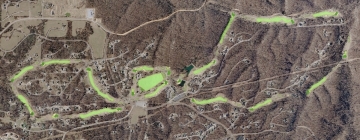
Every feature on a golf course can be accurately measured with either a GPS unit or through the use of imagery.  Imagery is a cost effective way to provide the superintendent  and his staff with additional information about the course.  All irrigation and drainage features can be added to the base map providing a detailed inventory of every component of the irrigation system including pipes (type, size, and length), sprinkler heads, valves, drains, and controllers.  This  information is compatible with most irrigation systems (e.g. Toro or Rainbird) and is a great communication tool for grounds personnel.  Save time, save money and increase efficiency:  Could there be a better reason for having an accurate as-built map of your golf course?  Accurate area measurements and square footage of tees, greens, fairways, sand traps, water, rough, and cart paths can be a crucial money saver.  Access to a digital golf course map instantly provides all the critical information needed for successful management and decision-making.   The GIS software calculates the area of each feature and summarizes it in a table.  This comes in handy when ordering seed, sand, and chemicals.   A full color wall map is designed displaying all tees, greens, fairways, bunkers, water bodies, cart paths, club house area, grounds keeper area, practice area and basic perimeter.   Please contact The Mapping Network for more information on golf course GPS mapping.

Golf GPS Data Collection
Collecting irrigation features using sub-foot GPS equipment
Golf Course
Golf Course features captured in the field using sub-foot accurate GPS units.
Irrigation Features GPS
Each irrigation feature was mapped in the field using sub-foot GPS technology. Data was implemented into golf course superintendents irrigation software program.

The Mapping Network: www.TheMappingNetwork.com A Nationwide Network of GPS Mapping Professionals