Wednesday, August 31, 2011

Engineers Developing Dredging Plan and Dock Placement Select Local Expert for Bathymetry Study

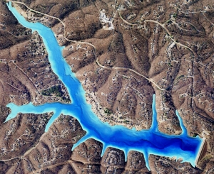
Smith Mountain Lake is a gorgeous, 40-mile long, 20,600 acre lake, with 500 miles of shoreline, nestled in the Blue Ridge Mountains of rural southwestern Virginia.  Part of an ongoing improvement project required small sections ranging from 0.25 to 3 acres to be dredged due to sedimentation and safety issues.   Another area of the lake was preparing for the installation of several docks for the increase in boaters.  In both cases, accurate bathymetric lake mapping conducted by SŌLitude Lake Management® and The Mapping Network was used as a tool for measuring lake depth and sediment volume to assist the lake in finding the best methods of dock placement and dredging techniques.  Engineers now have an updated basemap to monitor future sediment levels and keep boats traveling safely through the lake.

How accurate is your lake data? Did you know that many lake maps currently used by decision makers and the general public are either very old (often from the 1950′s) or were the original design plans (usually very inaccurate).  Don’t base your management and safety decisions on data that can be several feet off – have your lake mapped by the premier bathymetry survey providers in the country!  Only select companies undergo the detailed training provided through The Mapping Network.  This group of professional lake mappers have the local knowledge and reputation to proficiently map your lake.

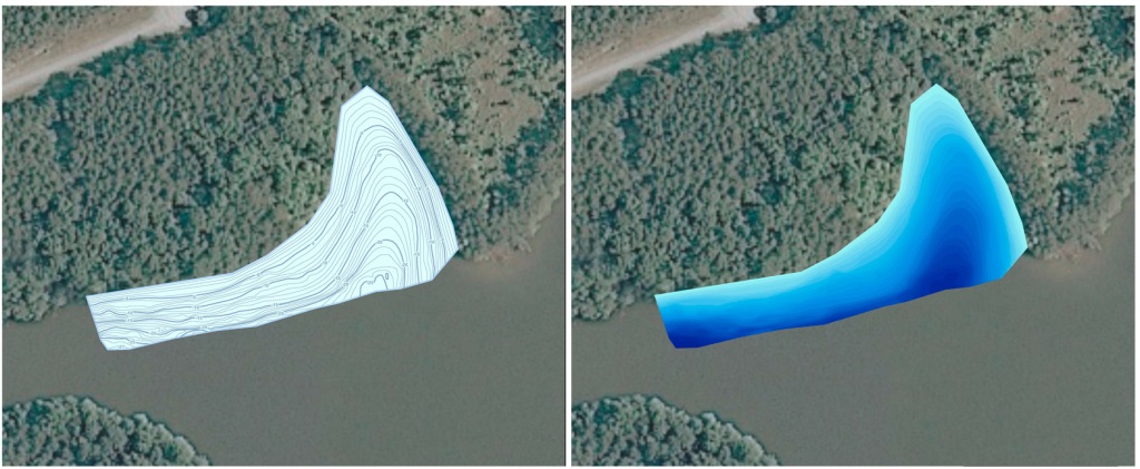
Contour and Color-Shaded Depth Map of study area by SŌLitude Lake Management®

Creating an accurate, up-to-date lake map of a cove. This information assists in construction and dredging plans by showing contractors and lake managers exactly what the bottom of the lake looks like.

SŌLitude Lake Management® Website on Lake Mapping:  http://www.solitudelakemanagement.com/services/lake-mapping/

Kevin Tucker is the president of SŌLitude Lake Management®, specializing in pond and lake management.  SŌLitude Lake Management® also controls pond management interests in West Virginia, Pennsylvania, Maryland, Delaware, and North Carolina.

phone: (866) 697-2584

website:  http://www.solitudelakemanagement.com

To learn more about our Sediment Mapping here >> Sediment Mapping Detailed

The Mapping Network is an industry leader in Geographic Information Systems Consulting, Data Conversion, and GPS Data Collection.  We specialize in terrain and sub-surface (bathymetry) GPS mapping.   If you are serious about maintaining  a high-quality golf course, lake or pond, be sure you have the ability to make the best decisions,  get your resource mapped by the professionals at The Mapping Network.   Give us a call or send an e-mail to find out more details.

phone:  (402) 241-8177

e-mail: info@themappingnetwork.com

website: www.themappingnetwork.com

Check out The Mapping Network on Facebook for more examples and success stories!


For the best results in mapping, it’s best to consult with a lake management company equipped with the very latest in GPS mapping technology.  Along with standard contour maps, The Mapping Network creates virtual media solutions on YouTube including a fly-over video and virtual underwater virtual swim-through.  With this knowledge, you can add layers of depth to the information you seek to maintain a beautiful lake.


Tuesday, August 30, 2011

Most lakes and ponds are fed by rivers and creeks and water isn’t the only thing being carried into the lake.  Something unseen is slowly accumulating on your lake bottom – Sediment.   When flooding occurs, the increased river levels cause extremely high amounts of sediment to be deposited into your lake.  Sedimentation is one of the costliest problems facing lakes due to the difficulty of removal.

If you live on a lake that is fed by a creek or river, there is a high need to monitor and map out sediment accumulation.
The Mapping Network teamed up with a local engineering company to map a marina on the Missouri River.  The purpose of this project was to determine the amount of sedimentation in the marina.  The Army Corps of Engineers used this information to gather bids for dredging the marina.  The post-dredge report declared an accurate bathymetric and sedimentation survey was collected and all parties were very satisfied with the results.

[caption id="attachment_2727" align="aligncenter" width="373" caption="Contour map with sediment thickness points of a marina on the Missouri River."][/caption]

To learn more about our Sediment Mapping here >> Sediment Mapping Detailed

The Mapping Network is an industry leader in Geographic Information Systems Consulting, Data Conversion, and GPS Data Collection.  We specialize in terrain and sub-surface (bathymetry) GPS mapping.   If you are serious about maintaining  a high-quality golf course, lake or pond, be sure you have the ability to make the best decisions,  get your resource mapped by the professionals at The Mapping Network.   Give us a call or send an e-mail to find out more details.

phone:  (402) 241-8177

e-mail: info@themappingnetwork.com

website: www.themappingnetwork.com

Check out The Mapping Network on Facebook for more examples and success stories!

Friday, August 26, 2011

This Highly Efficient Home and Forested Acreage is Spectacular!

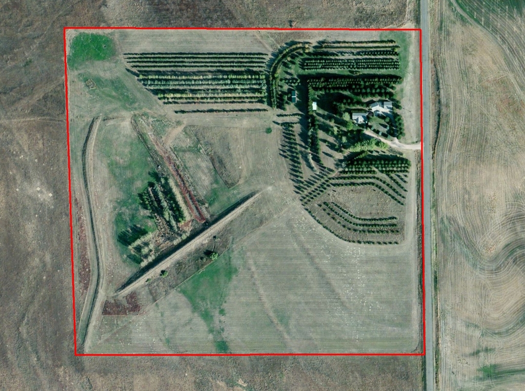
This 3,600 sq. ft. home is Impressive!  5 bedrooms with 3 bathrooms.  Country living in style.  There is also a separate facility that could serve as a man cave or guest house as well.  A 3 car garage tops off the class of this home in the country.  Also there are thousands of trees and shrubs planted on most of the acres.  This provides an oasis of cover for deer and antelope as well as pheasant, dove and other wildlife.  In addition, there is a water containment system that provides water for waterfowl.  The entire acreage is very well watered with 2 domestic wells.  This is a perfect home to enjoy wildlife.

For More Information
Contact Listing Agent Lucy Thierer 308-539-4260
lucy@lashleyland.com


For More information on this listing click here:  http://www.lashleyland.com/realestate/deuelcty_wildlife_hideout.html

View other Nebraska hunting properties from Lashley Land: www.lashleyland.com


[caption id="attachment_2701" align="aligncenter" width="581" caption="Aerial Map showing the "Deuel County Wildlife Hideout" listing from Lashley Land and Recreational Brokers."]nebraska land for sale map[/caption]


This property is also listed on the exclusive Cabela’s Trophy Properties website.

Contact For More Information
308-532-9300
info@lashleyland.com


Aerial, topography & location maps provided by The Mapping Network: www.TheMappingNetwork.com

The Mapping Network is an industry leader in Geographic Information Systems Consulting, Data Conversion, and GPS Data Collection.  We specialize in terrain and sub-surface (bathymetry) GPS mapping.   If you are serious about maintaining  a high-quality golf course, lake or pond, be sure you have the ability to make the best decisions,  get your resource mapped by the professionals at The Mapping Network.   Give us a call or send an e-mail to find out more details.

contact:  Steve Bartosh

phone:  (402) 241-8177

e-mail: info@themappingnetwork.com

website: www.themappingnetwork.com

Check out The Mapping Network on Facebook for more examples and success stories!


The Mapping Network is proud to announce their firm has been chosen by Cabela’s, the World’s Foremost Outfitter, as a Landowner Services provider for Cabela’s Trophy Properties throughout the United States.  Visit us on the Cabela’s Trophy Properties website >> click here


Thursday, August 25, 2011

The Barclays golf tournament has a rich history, starting life as the Westchester Classic in 1967 at the Westchester Country Club in Rye, New York. Various sponsors followed from 1976 until the first Barclays Classic in 2005. Two years later, The Barclays as we know it today was born when it became the first Playoff event in the FedExCup.

Designed by Donald J Ross in 1916 and completed in 1921, Plainfield Country Club’s majestic, top-ranked course (dubbed the 'Green Monster') presents a test of both skill and character. What's more, families and golf lovers alike have long revered Plainfield’s welcoming environment, beautiful setting and exceptional facilities.

Since its founding in 1890 as the Hillside Tennis Club, Plainfield has experienced tremendous growth, going on to host two US National Championships. The past 10 years have seen the Club undergo an extensive renovation program involving the removal of over 1,200 trees, the rediscovery of a number of lost bunkers, the expansion of 16 greens, and the lengthening of 12 tees to reflect modern equipment and skills.

The winner will walk away with $1,350,000 out of a total prize fund of $8,000,000.

Follow the leaderboard for the Wyndham Championship here:  LEADERBOARD

[googlemaps http://maps.google.com/maps?gl=us&vpsrc=6&sll=41.878002,-93.097702&sspn=4.324189,8.195801&ie=UTF8&t=h&ll=40.59336,-74.384716&spn=0.007332,0.012317&z=16&output=embed&w=575&h=450]

The Mapping Network is an industry leader in Geographic Information Systems Consulting, Data Conversion, and GPS Data Collection.  We specialize in terrain and sub-surface (bathymetry) GPS mapping.   If you are serious about maintaining  a high-quality golf course, lake or pond, be sure you have the ability to make the best decisions,  get your resource mapped by the professionals at The Mapping Network.   Give us a call or send an e-mail to find out more details.

contact:  Steve Bartosh

phone:  (402) 241-8177

e-mail: info@themappingnetwork.com

website: www.themappingnetwork.com

This classy place is set in the heart of the Beautiful pine ridge of Nebraska

This property features a beautiful home in simply a beautiful area! There is a high fence lot for livestock that has water running to it.

This 1st Class house features the following:
4 Bedrooms
Patio off the back
Main level: 1,970 sf - finished
Basement: 1,577 sf - finished

Hunting & recreation Opportunities
• White-tail Deer
Merriman's Wild Turkey

Literally just out the back door 3 Trophy white-tail deer were harvested. Several Merriman's have been taken on the property.

Make an appointment with Mike today to see this property! (308) 530–0134.

For More information on this listing click here:  http://www.lashleyland.com/realestate/pineridge_palace.html

View other Nebraska hunting properties from Lashley Land: www.lashleyland.com

[caption id="attachment_2673" align="aligncenter" width="491" caption="Aerial Map showing the "Pine Ridge Palace" listing from Lashley Land and Recreational Brokers."][/caption]

This property is also listed on the exclusive Cabela’s Trophy Properties website.


Contact For More Information
308-532-9300
info@lashleyland.com


Aerial, topography & location maps provided by The Mapping Network: www.TheMappingNetwork.com

The Mapping Network provides the highest quality and is the most affordable recreational land, lake mapping, and golf course mapping system on the market today.  If you are serious about maintaining  a high-quality property, golf course, lake or pond, be sure you have the ability to make the best decisions, contact the professionals at The Mapping Network.   Give us a call or send an e-mail to find out more details.

contact:  Steve Bartosh

phone:  (402) 241-8177

e-mail: info@themappingnetwork.com

website:

www.themappingnetwork.com

Check out The Mapping Network on Facebook for more examples and success stories!


The Mapping Network is proud to announce their firm has been chosen by Cabela’s, the World’s Foremost Outfitter, as a Landowner Services provider for Cabela’s Trophy Properties throughout the United States.  Visit us on the Cabela’s Trophy Properties website >> click here

Wednesday, August 24, 2011

Save Significant Money on Dredging Projects with The Mapping Network!


The Mapping Network recently completed a mapping project for a large-scale home owners association in Arkansas.  The large lake had 21 coves and several homeowners were having difficulties accessing their dock due to sedimentation.  Here were some of the questions the HOA management team had:

- where is the highest sedimentation occurring?

- how much fluffy sediment (in cubic yards) is in each cove?

- if the lake is drawn down 5 ft, what would the shoreline look like?

- how much water (gallons and acre-ft) is in the lake?

- if we make each cove a minimum of 4 feet deep for boat access how much material do we need to remove?

- by undertaking this mapping process will it save us money in the end?

The overall goal of the lake mapping project was to survey each cove for future dredging along with the creation of an accurate map of the entire lake.  The lake had 21 coves and The Mapping Network collected water depths over the entire lake and fluffy sediment levels for all areas under 10 feet of water.

3D models were generated to show how much sediment had accumulated in each cove.  Contour maps were also made for each cove and given to the lake manager and engineer to review for dredging planning.  The Mapping Network then created cut-fill calculations and maps based on the specifications of the lake manager.  The HOA then used this information as part of the bid package given to dredging companies.  Presenting the precise plans took out the guess work and kept all the dredging contractors on task and it is projected to save the HOA an estimated $5,000-$12,000 per cove!  An incredible cost savings when compiled over 21 coves.

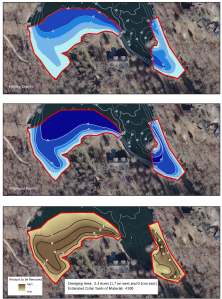
In the example maps below, The Mapping Network located the areas where the current depth was less than four feet, which was the dredging zone.  The mapping techniques utilized in this project helped the HOA accurately calculate and isolate areas of high sedimentation for removal and helped the property manager budget accordingly.

The bottom line – This powerful information allows for smart management and planning decisions and will serve as a baseline for future projects.  A great value!

A series of maps showing the seleceted area for dredging. The current lake bathymetry (top) and the post-dredge contours (middle) are shown in blue shading. A cut-fill model (bottom) shows areas of cut needed to reach the goal.
A series of maps showing the selected area for dredging.
The current lake bathymetry (top) and the post-dredge contours (middle)
are shown in blue shading. A cut-fill model (bottom) shows areas of cut
needed to reach the goal.


The Mapping Network provides the highest quality and is the most affordable bathymetric mapping system on the market today.  If you are serious about maintaining  a high-quality lake or pond, be sure you have the ability to make the best decisions,  get your lake mapped by the professionals at The Mapping Network.   Give us a call or send an e-mail to find out more details.

phone:  (402) 241-8177

e-mail: info@themappingnetwork.com

website: www.themappingnetwork.com

Check out The Mapping Network on Facebook for more examples and success stories!

Tuesday, August 23, 2011

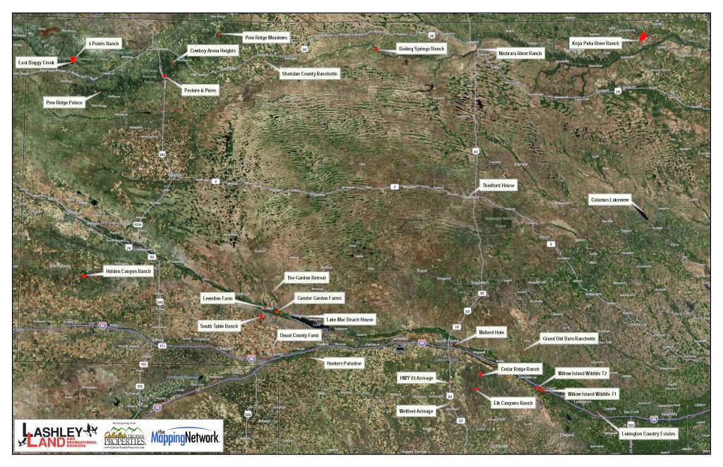
Lashley Land and Recreational Real Estate Brokers understands the value of providing accurate and timely information to their clients.  By teaming up with The Mapping Network, Lashley Land can easily communicate with buyers and sellers about their listings by showing the latest high resolution aerial imagery, topography, 3D and location maps.  These tools are invaluable in the recreational real estate market by showing a buyer detailed features the property from the comfort of their home or office.

Lashley Land has a map on file with all their current active listings so clients can easily visualize the inventory.  The application of this mapping technology reinforces the strong reputation and success of Lashley Land and Recreational Real Estate Brokers.  If you are interested in buying or selling land, contact Mike Lashley because he will use every tool at his disposal to make your dreams come true!

Contact For More Information
308-532-9300
info@lashleyland.com


[caption id="attachment_2647" align="aligncenter" width="574" caption="The active listings for Lashley Land and Recreational Real Estate Brokers. All maps area created by The Mapping Network"][/caption]

Aerial, topography & location maps provided by The Mapping Network: www.TheMappingNetwork.com

The Mapping Network provides the highest quality and is the most affordable recreational land, lake mapping, and golf course mapping system on the market today.  If you are serious about maintaining  a high-quality property, golf course, lake or pond, be sure you have the ability to make the best decisions, contact the professionals at The Mapping Network.   Give us a call or send an e-mail to find out more details.


contact:  Steve Bartosh

phone:  (402) 241-8177

e-mail: info@themappingnetwork.com

website:

www.themappingnetwork.com

Check out The Mapping Network on Facebook for more examples and success stories!


The Mapping Network is proud to announce their firm has been chosen by Cabela’s, the World’s Foremost Outfitter, as a Landowner Services provider for Cabela’s Trophy Properties throughout the United States.  Visit us on the Cabela’s Trophy Properties website >> click here

Friday, August 19, 2011


This ranch is in the incredible Pine Ridge area and is clearly very unique. Options are endless!


An additional 720 acres of land is available adjacent to this property.  See our East Boggy Creek listing.  This land includes a high fence timbered range as well. Enjoy the best of both worlds by purchasing 5 Points Ranch and East Boggy Creek. Open the gates on one and hunt deer - leave the other closed and hunt elk!

Call today to discuss in more detail.  308-532-9300

Hunting & recreation Opportunities

• Elk
• Merriam's Wild Turkey
• Trout - Brown and Rainbow
• Largemouth Bass
• Hybrid Sunfish
• Mule Deer (potential)
• White-tail Deer (potential)

This ranch is currently being used as a high fenced Elk Preserve, however, the elk could be removed and the gates opened to allow mule deer and white-tail deer to move in. The ranch could remain as is to enjoy a private elk herd to hunt without the need for permits.

The turkey are native and the trout ponds have been stocked with Brown Trout, Rainbow Trout, Largemouth Bass and Hybrid Sunfish.


For More information on this listing click here:  http://www.lashleyland.com/realestate/5points_ranch.html

[googlemaps http://maps.google.com/maps/ms?msa=0&msid=200316458506816603946.0004aade1ec9728e27dfc&hl=en&ie=UTF8&t=h&vpsrc=0&ll=42.76239,-103.686476&spn=0.022055,0.049353&z=14&output=embed&w=575&h=350]

View other Nebraska hunting properties from Lashley Land: www.lashleyland.com

This property is also listed on the exclusive Cabela’s Trophy Properties website.


Contact For More Information
308-532-9300
info@lashleyland.com


Mike Lashley and Lashley Land & Recreational Brokers – A Real Estate Service Like No Other!


Nebraska Farm and Ranch Land For Sale – Cabela’s Trophy Properties


Nebraska River Land For Sale – Waterfowl, Deer and Turkey Hunting

All aerial, topography and location maps provided by The Mapping Network: www.TheMappingNetwork.com

A Nationwide Network of GPS Mapping Professionals
Check out The Mapping Network on Facebook for more examples and success stories!


The Mapping Network is proud to announce their firm has been chosen by Cabela’s, the World’s Foremost Outfitter, as a Landowner Services provider for Cabela’s Trophy Properties throughout the United States.  Visit us on the Cabela’s Trophy Properties website >> click here


Thursday, August 18, 2011

Since 2008, The Wyndham Championship has been at Sedgefield Country Club and became the only regular-season event on the PGA TOUR contested on a course originally designed by famed architect, Donald Ross.
Follow the leaderboard for the Wyndham Championship here:  LEADERBOARD

[googlemaps http://maps.google.com/maps?hl=en&ie=UTF8&t=h&vpsrc=6&ll=36.010679,-79.882708&spn=0.01215,0.018239&z=15&output=embed&w=425&h=350]

The Mapping Network provides the highest quality and is the most affordable golf course and bathymetric mapping system on the market today.  If you are serious about maintaining  a high-quality golf course, lake or pond, be sure you have the ability to make the best decisions,  get your lake mapped by the professionals at The Mapping Network.   Give us a call or send an e-mail to find out more details.

contact:  Steve Bartosh

phone:  (402) 241-8177

e-mail: info@themappingnetwork.com

website: www.themappingnetwork.com

By , Sales Associate for Premier Outdoor Properties licensed in Nebraska and Kansas

It is pretty clear our Country’s debt and failing economy has a lot of people feeling scared and even threatened. Across the nation we are trying to adjust our bottom line and checking our assets. Many are planning new retirement plans and searching for new investment opportunities to help recover losses. If you are looking for a safe and stable investment, why not invest in Land?

I recently read an interesting study in Stanberry’s Investment Advisory, ‘The World’s Most Valuable Asset in a Time of Crisis’. ‘Since 1970, Farmland has outpaced gold, stocks, and just about any other asset we could name.’ That’s an astounding statistic. Add to it that ‘Farmland returns have little correlation to the returns on stocks and bonds’, and it didn’t fall in a single quarter during the financial meltdown, makes is it a safe investment with great returns.” (Stanberry’s Investment Advisory)

I know in today’s unstable economy and skeptical investment environment, this news seems to good to be true. I found through further research that the sentiment of Stanberry’s outlook on farmland is consistent. Bloomberg supports the idea declaring, ‘Farmland and forestry will outperform the average of all global assets long-term’.

Land is a stable market with great long-term returns. Additionally, land may give you an immediate return on your investment though grazing, farming, and hunting leases that can provide an increase in cash flow. The best part is you can have your own place to go hunting and fishing.

It’s very clear that the demand for land is on the rise. We are already experiencing a strong demand from savvy investors looking to beat the rush, making it a great time to sell your property too. Ultimately, land is one of our most valuable assets and as they say ‘they aren’t making any more of it.’


All aerial, topography and location maps for Premier Outdoor Properties provided by The Mapping Network: www.TheMappingNetwork.com

A Nationwide Network of GPS Mapping Professionals
Check out The Mapping Network on Facebook for more examples and success stories!


The Mapping Network is proud to announce their firm has been chosen by Cabela’s, the World’s Foremost Outfitter, as a Landowner Services provider for Cabela’s Trophy Properties throughout the United States.  Visit us on the Cabela’s Trophy Properties website >> click here

Tuesday, August 16, 2011


This Little Ranch is Full of Elk, Mule Deer, Whitetail Deer and Wild Turkey. Secluded, But Good Access.

This ranch little ranch has it all.  Elk, Mule Deer, White-tailed Deer, Wild Turkey, Dove, Pheasant and more.  There is currently a 7 acre + alfalfa field located in the middle of the tract.  There are 3 additional fields that used to be in C.R.P. and could be farmed to create additional food plots.  The owner has trail cam photos that are impressive.  This would make a great hunting ranch.  Power is close by with lots of great building sites.


For More information on this listing click here:  http://www.lashleyland.com/realestate/elkcanyons_ranch.html


[googlemaps http://maps.google.com/maps/ms?msa=0&msid=200316458506816603946.0004aa9f8900963f6874f&ie=UTF8&vpsrc=6&ll=40.864004,-100.556402&spn=0.022719,0.036478&z=14&output=embed&w=425&h=350]

View other Nebraska hunting properties from Lashley Land: www.lashleyland.com

This property is also listed on the exclusive Cabela’s Trophy Properties website.


Contact For More Information
308-532-9300
info@lashleyland.com


Mike Lashley and Lashley Land & Recreational Brokers – A Real Estate Service Like No Other!


Nebraska Farm and Ranch Land For Sale – Cabela’s Trophy Properties


Nebraska River Land For Sale – Waterfowl, Deer and Turkey Hunting

All aerial, topography and location maps provided by The Mapping Network: www.TheMappingNetwork.com

A Nationwide Network of GPS Mapping Professionals
Check out The Mapping Network on Facebook for more examples and success stories!


The Mapping Network is proud to announce their firm has been chosen by Cabela’s, the World’s Foremost Outfitter, as a Landowner Services provider for Cabela’s Trophy Properties throughout the United States.  Visit us on the Cabela’s Trophy Properties website >> click here


Monday, August 15, 2011

Most lakes and ponds are fed by rivers and creeks and water isn't the only thing being carried into the lake.  Something unseen is slowly accumulating on your lake bottom - Sediment.   When flooding occurs, the increased river levels cause extremely high amounts of sediment to be deposited into your lake.  Sedimentation is one of the costliest problems facing lakes due to the difficulty of removal.  If you live on a lake that is fed by a creek or river, there is a high need to monitor and map out sediment accumulation.  Learn more about our Sediment Mapping here >> Sediment Mapping Detailed

Here at The Mapping Network, we specialize in accurately mapping bodies of water, calculating the water volume, collecting sediment depth samples at critical areas and monitoring the distribution of sediment over time.  We have a nationwide group of professionals specializing in all facets of lake management.   If you are serious about maintaining  a high-quality lake or pond, be sure you have the ability to make the best decisions,  get your lake mapped by the professionals at The Mapping Network.   Give us a call or send an e-mail to find out more details.

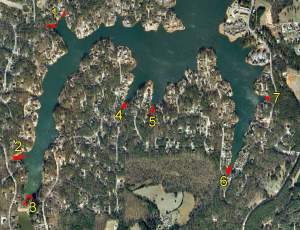
[caption id="attachment_2614" align="aligncenter" width="300" caption="Locations of sediment depth points collected. Each cover where a creek entered the lake was surveyed for sedimentation. The results of this project will assist lake managers in creating dredging plans."][/caption]

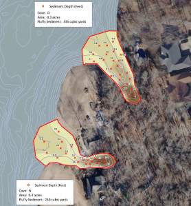
[caption id="attachment_2615" align="aligncenter" width="278" caption="Map displaying sediment depths with color-shading to visualize the areas of high sedimentation."][/caption]

contact:  Steve Bartosh

phone:  (402) 241-8177

e-mail: info@themappingnetwork.com

website: www.themappingnetwork.com


A Nationwide Network of GPS Mapping Professionals

Thursday, August 11, 2011

[caption id="attachment_2607" align="aligncenter" width="300" caption="3D Color-shaded depth map showing the unique characteristics under the surface of a lake"]3D Lake Map[/caption]

To fully enjoy your lake or pond it is essential to know the facts.  Exact acreage, depths, and chemistry of your lake are critical factors for making the best management decisions.  Armed with this knowledge you will be able to properly place structure, deliver appropriate stocking densities, select the correct fish species, apply the right amount of weed control, and of course gain a better idea where those bass may be hiding!

Equipped with the very latest in GPS surface mapping, bathymetry, 3-D contour imaging, aerial and fly-over video resources and virtual underwater swim-view 3-D mapping, we are able to add layers of depth to the information our customers seek. Whether you are tracking sedimentation, planning for dredging, looking to improve your fishery, or simply looking to understand the overall size, volume, and bottom contour of your pond in order to make good management decisions, we have the tools you need to be successful.

The Mapping Network maps lakes throughout the entire year all across the nation.  An accurate lake map provides the information needed to make the most of your aquatic resource.   The Mapping Network provides the highest quality and is the most affordable bathymetric mapping system on the market today.  If you are serious about maintaining  a high-quality lake or pond, be sure you have the ability to make the best decisions,  get your lake mapped by the professionals at The Mapping Network.   Give us a call or send an e-mail to find out more details.

contact:  Steve Bartosh

phone:  (402) 241-8177

e-mail: info@themappingnetwork.com

website: www.themappingnetwork.com

We invite you to follow our company page of LinkedIn for the latest information on The Mapping Network.

http://www.linkedin.com/company/the-mapping-network

The Mapping Network provides the highest quality and is the most affordable golf course and bathymetric mapping system on the market today.  If you are serious about maintaining  a high-quality golf course, lake or pond, be sure you have the ability to make the best decisions,  get your lake mapped by the professionals at The Mapping Network.   Give us a call or send an e-mail to find out more details.

contact:  Steve Bartosh

phone:  (402) 241-8177

e-mail: info@themappingnetwork.com

website: www.themappingnetwork.com

Wednesday, August 3, 2011


Save Significant Money on Dredging Projects with The Mapping Network!   The Mapping Network recently completed a mapping project for a large-scale home owners association in Arkansas.  The large lake had 21 coves and several homeowners were having difficulties accessing their dock due to sedimentation.  Here were some of the questions the HOA management team had:- where is the highest sedimentation occurring?

- how much fluffy sediment (in cubic yards) is in each cove?

- if the lake is drawn down 5 ft, what would the shoreline look like?

- how much water (gallons and acre-ft) is in the lake?

- if we make each cove a minimum of 4 feet deep for boat access how much material do we need to remove?

- by undertaking this mapping process will it save us money in the end?

The overall goal of the lake mapping project was to survey each cove for future dredging along with the creation of an accurate map of the entire lake.  The lake had 21 coves and The Mapping Network collected water depths over the entire lake and fluffy sediment levels for all areas under 10 feet of water.

3D models were generated to show how much sediment had accumulated in each cove.  Contour maps were also made for each cove and given to the lake manager and engineer to review for dredging planning.  The Mapping Network then created cut-fill calculations and maps based on the specifications of the lake manager.  The HOA then used this information as part of the bid package given to dredging companies.  Presenting the precise plans took out the guess work and kept all the dredging contractors on task and it is projected to save the HOA an estimated $5,000-$12,000 per cove!  An incredible cost savings when compiled over 21 coves.

In the example maps below, The Mapping Network located the areas where the current depth was less than four feet, which was the dredging zone.  The mapping techniques utilized in this project helped the HOA accurately calculate and isolate areas of high sedimentation for removal and helped the property manager budget accordingly.

The bottom line – This powerful information allows for smart management and planning decisions and will serve as a baseline for future projects.  A great value!

A series of maps showing the seleceted area for dredging. The current lake bathymetry (top) and the post-dredge contours (middle) are shown in blue shading. A cut-fill model (bottom) shows areas of cut needed to reach the goal.
A series of maps showing the selected area for dredging.
The current lake bathymetry (top) and the post-dredge contours (middle)
are shown in blue shading. A cut-fill model (bottom) shows areas of cut needed to reach the goal.


The Mapping Network provides the highest quality and is the most affordable bathymetric mapping system on the market today.  If you are serious about maintaining  a high-quality lake or pond, be sure you have the ability to make the best decisions,  get your lake mapped by the professionals at The Mapping Network.   Give us a call or send an e-mail to find out more details.

phone:  (402) 241-8177

e-mail: info@themappingnetwork.com

website: www.themappingnetwork.com