Tuesday, June 29, 2010

The Mapping Network and Golf Course / Athletic Field Construction Specialist Team Up

The Mapping Network has developed a proprietary process to derive accurate cut and fill calculations utilizing existing digital design (CAD) and the architects proposed design.  Mid-America Golf and Landscape, a Kansas City based Golf Course and Athletic field construction company, has been utilizing this service for several years.  A great benefit of having a digital golf course map is the instant access to area calculations of all course features.  During the bidding process, having access to extremely accurate area measurements and square footages of tees, greens, fairways, sand traps, water, rough, and cart paths allows Mid-America Golf and Landscape to develop an accurate bid.  The Mapping Network also has the capability to accurately calculate cut/fill calculations for the entire course, or hole by hole.  This process allows the contractor to visualize where significant amounts of dirt will be moved, and assists in determining the shortest distance to transfer a load of soil. This can be a crucial money saver for  the owner.

Dirt Quantity Analysis for a golf course renovation in Florida. Areas of red are cuts and blue areas require fill

Mid-America Golf and Landscape is a GCBAA certified full service golf course contractor dedicated to Creating the Total Golf Experience. They have turned the dreams and plans of our public and private sector clients into reality through:
  • New golf course construction
  • Full golf course construction feature renovations
  • Golf course drainage and irrigation installation only projects
  • Athletic field construction
Give us a call 816.524.0010 or visit our website to find out more information:  www.mid-americagolf.com

Mid America Golf and Landscape


The Mapping Network:  www.TheMappingNetwork.com
A Nationwide Network of GPS Mapping Professionals

100 acres of land
1000 acres of land
10,000 acres of land
100,000 acres of land


Monday, June 28, 2010

Lake Bathymetry in Denver, Colorado

Lake Mapping used to Understand Depths and Volume of Reservoir

Upper Soda Lake, part of a popular recreation area in Lakewood, Colorado (suburb of Denver) was recently mapped by Absolute Natural Resources, LLC.  The resulting bathymetric lake map will assist management decisions by understanding the topography of the bottom of the reservoir.  The public will also enjoy the benefits of a new, accurate lake map by easily identifying areas to fish.

More information on Absolute Natural Resources, LLC can be found on their website: www.anrwildlife.com

Bathymetry of Upper Soda Lake in Lakewood, Colorado

The Mapping Network: www.TheMappingNetwork.com
A Nationwide Network of GPS Mapping Professionals

Need a Large Wall Map of your favorite lake, property or hunting area, or golf course? The Mapping Network provides a low cost mapping product for the outdoor enthusiast!  Just let us know what area you want and we will print and ship a beautiful full-color wall map using the best aerial imagery available.

Create your own Aerial Maps here: Make My Own Map

Republican River Land For Sale in Webster County, Nebraska

Outstanding Nebraska Hunting Land For Sale: More Than A Mile of Republican River Frontage. Heavy Timber, Alfalfa and Corn Make for Lots of Wildlife.

This part of the Republican River has some of the best accretion ground I’ve seen. Heavily wooded with over a mile of river frontage. This piece of river could be developed with center pivot irrigation. There are 4 irrigation wells in place. Plenty of water for irrigation. The dry crop hay ground is isolated within the accretion making for perfect hunting areas especially with food plot development.

For More information on this listing click here:  http://www.lashleyland.com/realestate/republicanriver_whitetails.html

View other Nebraska hunting properties from Lashley Land: www.lashleyland.com

Beautiful Hunting and Ag Land For Sale in Webster County, Nebraska
 
Mike Lashley and Lashley Land & Recreational Brokers – A Real Estate Service Like No Other!Nebraska Farm and Ranch Land For Sale – Cabela’s Trophy PropertiesNebraska River Land For Sale – Waterfowl, Deer and Turkey Hunting 
 
All aerial, topography and location maps provided by The Mapping Network:  www.TheMappingNetwork.com
A Nationwide Network of GPS Mapping Professionals

Need a Large Wall Map for your property or hunting area? The Mapping Network provides a low cost mapping product for the outdoor enthusiast!  Just let us know what area you want and we will print and ship a beautiful full-color wall map using the best aerial imagery available.

Create your own Aerial Maps here: Make My Own Map

Prime Nebraska Hunting Land For Sale: 2 Miles of the Birdwood Creek Runs Through This Property in Lincoln County, Nebraska

This pasture is the classic Sandhills of Nebraska.  This property is located in the heart of the famous Ogallala Aquifer, the largest underground water supply in the world!  There are 2 miles of the Birdwood Creek running through this property.  The creek has never run dry because it is spring fed from the Ogallala Aquifer.  In addition, there are 3 windmills that provide plenty of water for livestock.  This property is only 20 minutes from Interstate 80 and has oil road to the west side.  Own a piece of history, as well as have a hunting spot.  Mule deer, antelope, sharptail Grouse, prairie chicken and waterfowl are present.

For More information on this listing click here:  http://www.lashleyland.com/realestate/birdwoodcreek_ranch.html

View other Nebraska hunting properties from Lashley Land: www.lashleyland.com

Nebraska Hunting Land For Sale along Birdwood Creek in Lincoln County, Nebraska

Mike Lashley and Lashley Land & Recreational Brokers – A Real Estate Service Like No Other!
Nebraska Farm and Ranch Land For Sale – Cabela’s Trophy Properties

Nebraska River Land For Sale – Waterfowl, Deer and Turkey Hunting

All aerial, topography and location maps provided by The Mapping Network:  www.TheMappingNetwork.com

A Nationwide Network of GPS Mapping Professionals

Need a Large Wall Map for your property or hunting area? The Mapping Network provides a low cost mapping product for the outdoor enthusiast!  Just let us know what area you want and we will print and ship a beautiful full-color wall map using the best aerial imagery available.

Create your own Aerial Maps here: Make My Own Map

Aerial Imagery Printing Service

Need a Large Wall Map for your property or hunting area? The Mapping Network provides a low cost mapping product for the outdoor enthusiast!  Pick your favorite lake, golf course or hunting location and have a high-quality 24 inch or 36 inch wall map printed for the home, office, or cabin.  This unique map will be enjoyed for many years to come. 

Just let us know what area you want and we will print and ship a beautiful full-color wall map using the best aerial imagery available.  All for an amazing low price!

Click here to Order a Wall Map

Wall Maps of your favorite golf course, lake or property!

The Mapping Network – Professional GPS /GIS Mapping and Printing Services-

Bathymetry Validates Dredging Project

3D GPS Bathymetric Lake Mapping verifies Dredging Project
Arlington, Texas – Trent Lewis with Pond Medics, Inc. completed a bathymetric survey in conjunction with a golf course management company and a dredging company to verify appropriate sediment removal was achieved during a dredging project.  Pond Medics, a lake mapping partner with The Mapping Network, charted the bottom of the lake before and after the dredging project to monitor the improvements.  This information provides peace of mind to the owner and also validates work completed by the contractor, so the lake map benefits both parties.  Not only was the management team of the golf course able to verify the work had been completed according to plan but they now have a basemap to  monitor sediment accumulation in the future.  Many golf courses require accurate volume numbers for their ponds because of heavy irrigation. Periodic GPS bathymetric mapping provides this critical volume information and monitors potential areas of sediment or nuisance aquatic vegetation.

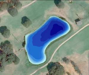
GPS Lake Map of golf course pond after dredging was completed
More information on Pond Medics can be found on their website:  www.pondmedics.com

The Mapping Network:  www.TheMappingNetwork.com
A Nationwide Network of GPS Mapping Professionals

Bathymetry Partner Spotlight: Pond Medics, Inc

PondMedics Incorporated is the complete source for your pond and lake needs in Texas and Oklahoma.  In addition to managing private fisheries, controlling aquatic vegetation and the typical lake management services, PondMedics also offers engineering services specifically for ponds and lakes.  Setting themselves apart from other pond and lake management companies, PondMedics Incorporated is a State of Texas registered Civil Engineering firm specializing in limnology, bathymetry, hydraulics and hydrology to help you design, engineer and renovate your pond or lake.  PondMedics’ strategic partnership with The Mapping Network allows them to offer lake mapping technology to clients for a wide variety of uses.  In just the past year, GPS Lake Mapping completed by PondMedics has saved clients over $100,000 in unnecessary engineering and dredging costs.  The diversity of services focuses on the holistic approach to managing ponds and lakes, ensuring their sustainability for future generations.

Give PondMedics a call or visit their website to find out more information.
Trent Lewis
phone: (972) 334-0104
e-mail:  info@pondmedics.com
website:  www.pondmedics.com

PondMedicsLogo
Note:  A full list of certified members of The Mapping Network is found on the right-hand side of the blog under “Partners”
The Mapping Network:  www.TheMappingNetwork.com
A Nationwide Network of GPS Mapping Professionals

GPS Lake Map

GPS Bathymetric Lake Map

Bathymetry and a Creative Design Saves Community Hundreds of Thousands of Dollars

Chicago Area Company uses Technology to Save Community Significant Money

A reserve study at a local eco-friendly community said that the community needed to save over a half million dollars over a 30 year period for a future dredging project due to increased sedimentation from storm water runoff.  This was based on a 2005 bathymetric study performed by Integrated Lakes Management.  This subdivision  is a very environmentally conscious and developed a treatment train to route its stormwater through prairies, swales and wetlands.  Most of the sediment likely washed in with the initial construction and has decreased significantly due to the treatment train.  A new bathymetric mapping survey conducted in 2009, utilizing the Mapping Network’s technology, revealed there was no net gain of sediment in the lake within the four year period!  This verification by bathymetric survey saved the community  hundreds of thousands of dollars by not assuming sedimentation had occurred thus mobilizing a dredging project that in the end was not necessary.  Part of the ongoing management plan is to map the lake every year to monitor sediment levels over time. 

For more information on how Integrated Lakes Management utilizes GPS lake mapping and other conservation techniques please call or send an e-mail.

Phone:  847-244-6662
e-mail:  kgray@lakesmanagement.com
Website: www.lakesmanagement.com


The Mapping Network:  www.TheMappingNetwork.com
A Nationwide Network of GPS Mapping Professionals

Lake Mapping Spotlight: Aquatechnex

Aquatechnex is a fully integrated lake and aquatic plant management firm that operates primarily in the Western United States and Upper Midwest States.  The company is a recognized expert in the management of invasive aquatic species such as Eurasian Milfoil, Brazilian Elodea, Hydrilla and Water Hyacinth.  The mission of Aquatechnex is to provide solutions to insure the beneficial uses of their clients water bodies are protected.  GPS Bathymetry is a critical management tool for isolating areas of potential invasive vegetation growth.  Lake mapping projects by Aquatechnex have been completed in Arizona, California, Oregon and Washington.  Aquatechnex is a nationwide leader in the development and implementation of effective programs using integrated lake and aquatic plant management technologies.  They strive to be the best and be a company that lake groups will seek out for expertise.

Give Aquatechnex a call or visit their website to find out more information.

Terry McNabb
phone: (208) 338-8490
e-mail:  tmcnabb@aquatechnex.com
website:  www.aquatechnex.com
blog:  http://aquatechnex.wordpress.com/
AQT Clr Logo1
Note:  A full list of certified members of The Mapping Network is found on the right-hand side of the blog under “Partners”
The Mapping Network:  www.TheMappingNetwork.com
A Nationwide Network of GPS Mapping Professionals

GPS Lake Map

GPS Bathymetric Lake Map

Tuesday, June 1, 2010

Loup County, Nebraska Lake Property For Sale

Calamus Reservoir Property For Sale

Great View of the Calamus Reservoir in Loup County, Nebraska
Here is a beautiful 49.8 acre parcel overlooking the Calamus Reservoir on the North side of the lake. There is highway access and some cedar trees with lush grass on this very sought after piece of Loup County ground. There is also and old school house on the property that in uninhabitable, but could be turned into a nice lake cabin. If you are looking for a place to turn into your summer recreational spot, look no further. Turkeys are abundant and live near this property. Call listing agent, Scott Saults, at 308-289-1383 for more information.

For More information on this listing click here:  http://www.lashleyland.com/realestate/calamus_lakeview.html

View other Nebraska hunting properties from Lashley Land: www.lashleyland.com


Aerial map of a beautiful 49.8 acre parcel overlooking the Calamus Reservoir
Mike Lashley and Lashley Land & Recreational Brokers – A Real Estate Service Like No Other!
Nebraska Farm and Ranch Land For Sale
Nebraska River Land For Sale – Waterfowl, Deer and Turkey Hunting

All aerial, topography and location maps provided by The Mapping Network:  www.TheMappingNetwork.com

A Nationwide Network of GPS Mapping Professionals

Need a Hunting Map for a small price? The Mapping Network and MyTopo have teamed up to provide a low cost mapping product for the outdoor enthusiast!

Create your own Aerial and Topo Maps here: Make My Own Map