Wednesday, June 15, 2011

Lake of the Ozarks Mile Marker Aerial Map – Fathers Day Gift!

If you live on or visit the Lake of the Ozarks then you understand the importance of navigating the lake by Mile Markers.  The Mapping Network has created an aerial map of The Lake of The Ozarks with Mile Markers from the Truman Dam to the Bagnell Dam.  This map is offered is several sizes and formats.

Order a Mile Marker Map of The Lake of the Ozarks here:  Map Store
Lake of The Ozarks Mile Marker Aerial Imagery Map. Watermark is removed on printed map.
Example of 24 inch wall map placed in a frame (not included). Beautiful addition to any home, cabin or office.
The Mapping Network is offering beautiful large format printings of your favorite recreational location.  If you have a lake home or cabin, there is no better accessory than a wall map of your lake!  Our color enhanced aerial imagery maps utilize the latest imagery available and are printed on industry leading printers and high quality photo or bond paper.

The Mapping Networkprovides a low cost mapping product for the outdoor enthusiast!Pick your favorite lake, golf course or hunting location and have a high-quality 24 inch or 36 inch wall map printed for the home, office, or cabin.  This unique map will be enjoyed for many years to come.
Just let us know what area you want and we will print and ship a beautiful full-color wall map using the best aerial imagery available.  All for an amazing low price!
Click here to Order a Wall Map

Aerial Imagery Wall Maps for any lake, golf course, or property in the country!
For the Recreational Real Estate Market show your clients and buyers the entire property on one up-to-date full-color aerial map.  If you have hunting land for sale you want to know if that field, lake, or bluff is 1 acre, 10 acres, 100 acres or 10,000 acres of land.  This is a great way for real estate professionals to promote a listing in the office, on-site, or at an auction.  Take control of your listings and get a leg up on your competition.
 
Never underestimate the power of a professionally created map to generate buzz about your brokerage or listings.


The Mapping Network – Professional GPS /GIS Mapping and Printing

The Mapping Network on Facebook

Check out The Mapping Network on Facebook for more examples and success stories! 


Equipped with the very latest in GPS surface mapping, bathymetry, 3-D contour imaging, aerial and fly-over video resources and virtual underwater swim-view 3-D mapping, we are able to add layers of depth to the information our customers seek. Whether you are tracking sedimentation, planning for dredging, looking to improve your fishery, or simply looking to understand the overall size, volume, and bottom contour of your pond in order to make good management decisions, we have the tools you need to be successful.

Nebraska Land For Sale – Cabela’s Trophy Properties

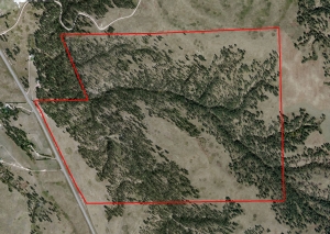
Approximately 350 acres of beautiful Pine Ridge Country with Highway 385 running along the west side for great access and several great locations for building site.  Panoramic views of the Pine Ridge with its great location will make this property very desirable now and in the future.  There are mule deer, white-tailed deer and Merriams Wild turkey on the property.  Elk also travel through the land as well.  There are deep canyons and the land is approximately 75% tree covered.  Chadron, Nebraska has a commercial airport (5,700 ft of runway) and a State College.  Population 5,851.  Sellers would consider selling smaller tracts.  Survey will be done to determine exact boundaries.  Contact Scott for more information regarding location and pricing:  308-289-1383 or scott@lashleyland.com

For More information on this listing click here:  http://www.lashleyland.com/realestate/pasture_pines.html

View other Nebraska hunting properties from Lashley Land: www.lashleyland.com

This property is also listed on the exclusive Cabela’s Trophy Properties website.

Contact Listing Agent
Scott Saults
308-289-1383
scott@lashleyland.com


Aerial map of "Pasture & Pines" for sale in Dawes County, Nebraska

Mike Lashley and Lashley Land & Recreational Brokers – A Real Estate Service Like No Other!
Nebraska Farm and Ranch Land For Sale – Cabela’s Trophy Properties
Nebraska River Land For Sale – Waterfowl, Deer and Turkey Hunting
All aerial, topography and location maps provided by The Mapping Network: www.TheMappingNetwork.com

New Jersey GPS Lake Map

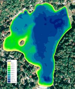
The Mapping Network and Allied Biological completed a lake mapping project for a client in New Jersey.  The client is this case is a community association that manages 6 water bodies. The purpose was to give the client more accurate information about the lake, which had never been mapped to this detail before.  This is their 3rd largest lake and the community has already mapped the two larger lakes with the professionals at The Mapping Network and Allied Biological.   The bathymetry map assists Allied Biological, as their lake managers, in developing better management strategies, ie: determining herbicide application rates,  focusing on areas that may support nuisance plant growth and sediment accumulation, and locate suitable areas for in-lake plantings or aeration systems.

Since 1982, Allied Biological has been an industry leader in providing lake management consulting and wetland restoration solutions. With an experienced, year-round staff comprised of biologists, environmental scientists and aquatic habitat specialists, our company manages and restores more than 20,000 acres of ponds, lakes, reservoirs and wetlands using a variety of management techniques.Allied Biological provides the largest range of lake and wetland services for New York, New Jersey, Pennsylvania and Delaware including:
  • Lake Mapping: bathymetric lake mapping, aquatic vegetation mapping, invasive wetland species mapping
  • Fisheries Management: fisheries studies, fish removal, fish stocking
  • Lake Weed and Algae Control: weed removal through hydro-raking, chemical applications, biomanipulation
  • Consulting Services: water quality assessment, feasibility studies, vegetation management plans, lake management plans
  • Lake Aeration: Freshlake Aeration and floating fountains
  • Wetland Vegetation Control: mechanical removal and chemical applications to control invasive species
For more information about Allied Biological or any of our aquatic restoration & management services, please contact us at 908-850-0303.
In northern New York, please contact us at 607-286-7257.
More information on Allied Biological can be found on their website:  www.alliedbiological.com
Color shaded depth map showing the current lake depths in one foot intervals.

The Mapping Network:  The Mapping Network is a nationwide group of professionals providing the highest quality and most affordable bathymetric and land mapping products on the market today. Our staff has been using GIS and GPS technology for land and water services since 1995. Over the years we have developed proprietary technologies for data collection, analysis and map generation. We have shared our technology with a select group of companies throughout the nation to form the largest, most affordable, and highest quality products of its kind.

New Jersey Lake Mapping: Before and After Dredging

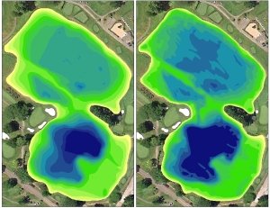
The Mapping Network and Allied Biological recently completed a lake mapping project for a country club in New Jersey.  The client initially requested the creation of a detailed lake map for understanding true depths, volume analysis and to identify areas needed for dredging.  Upon receiving the results of the lake map, the country club was able to efficiently locate areas for dredging and take control of the bidding process.

After the completion of the dredging portion, the country club immediately remapped the lake to verify the dredging company had taken out the correct amount of material and also to establish a new base map.  The new map will be used to generate a lake management plan for water conservation and future dredging.

The lake mapping process allowed the client to make intelligent decisions on their dredging project and gave them the peace of mind knowing the work has been completed properly.
Since 1982, Allied Biological has been an industry leader in providing lake management consulting and wetland restoration solutions. With an experienced, year-round staff comprised of biologists, environmental scientists and aquatic habitat specialists, our company manages and restores more than 20,000 acres of ponds, lakes, reservoirs and wetlands using a variety of management techniques.Allied Biological provides the largest range of lake and wetland services for New York, New Jersey, Pennsylvania and Delaware including:
  • Lake Mapping: bathymetric lake mapping, aquatic vegetation mapping, invasive wetland species mapping
  • Fisheries Management: fisheries studies, fish removal, fish stocking
  • Lake Weed and Algae Control: weed removal through hydro-raking, chemical applications, biomanipulation
  • Consulting Services: water quality assessment, feasibility studies, vegetation management plans, lake management plans
  • Lake Aeration: Freshlake Aeration and floating fountains
  • Wetland Vegetation Control: mechanical removal and chemical applications to control invasive species
For more information about Allied Biological or any of our aquatic restoration & management services, please contact us at 908-850-0303.
In northern New York, please contact us at 607-286-7257.
More information on Allied Biological can be found on their website:  www.alliedbiological.com
Color shaded depth map showing the pre-dredge (left) and post-dredge (right) lake depths

The Mapping Network:  The Mapping Network is a nationwide group of professionals providing the highest quality and most affordable bathymetric and land mapping products on the market today. Our staff has been using GIS and GPS technology for land and water services since 1995. Over the years we have developed proprietary technologies for data collection, analysis and map generation. We have shared our technology with a select group of companies throughout the nation to form the largest, most affordable, and highest quality products of its kind.

Niobrara River View – Cabela’s Trophy Properties

What A View Overlooking The Niobrara River!
How Would You Like This For Your Backyard?


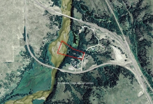
This property is riverside complete with 4 bedrooms, 4 bath, 3,992 sq. ft. with 2 fireplaces, wet-bar, beautiful hardwood floors, oak cabinets, cathedral ceilings, office and study, Jacuzzi tub, walk-in closet, 2 decks, 40×40 barn with office and stalls on 8.9 acres.   Geese, turkey and deer are abundant on this place.  This is a MUST SEE! Seller requests showings to prequalified buyers only. 

Area attractions include Authur Bowring Ranch, Cowboy Trail, City of Valentine, Fort Niobrara Refuge, Merritt Reservoir, Nebraska Sandhills, The Famous National Niobrara Scenic River designated by Congress in 1991, Rosebud Reservation, Smith Falls State Park and The Valentine Wildlife Refuge.
For More information on this listing click here:  http://www.lashleyland.com/realestate/niobrarariver_view.html
View other Nebraska hunting properties from Lashley Land: www.lashleyland.com

This property is also listed on the exclusive Cabela’s Trophy Properties website.

Contact Listing Agent
Lucy Thierer
Office: 308-532-930

Cell 308-539-4260
lucy@lashleyland.com


Aerial map of "Niobrara River View" for sale in Cherry County, Nebraska

Nebraska Farm and Ranch Land For Sale – Cabela’s Trophy Properties 
Nebraska River Land For Sale – Waterfowl, Deer and Turkey Hunting


All aerial, topography and location maps provided by The Mapping Network: www.TheMappingNetwork.com
A Nationwide Network of GPS Mapping Professionals

Need a Large Wall Map for your property or hunting area? The Mapping Network provides a low cost mapping product for the outdoor enthusiast!  Just let us know what area you want and we will print and ship a beautiful full-color wall map using the best aerial imagery available.

Create your own Aerial Maps here: Make My Own Map

The Mapping Network is proud to announce their firm has been chosen by Cabela’s, the World’s Foremost Outfitter, as a Landowner Services provider for Cabela’s Trophy Properties throughout the United States.  Visit us on the Cabela’s Trophy Properties website >> click here