Friday, August 20, 2010

Platte River Hunting Property For Sale

Trophy Whitetail Deer and Turkey – Near Maxwell, Nebraska on the Platter River

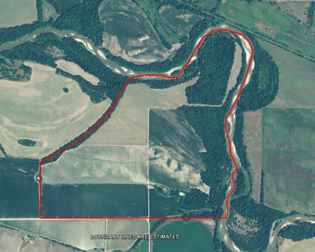
Both Side of a Platte River Channel. This Little Jewel has Tremendous Bedding Cover.
This little piece of heaven could provide a huge dividend in deer harvest.  It’s one of those places that attract whitetails.  There is cropland north and south of this property.  Game trails are abundant.  I bumped a nice Tom coming into the tract to take pictures.  I also think that one could have decent early season waterfowl hunting with the river and ponds that exist on the property.  All this at a very affordable price.

For More information on this listing click here:  http://www.lashleyland.com/realestate/mcpherson_whitetails.html

View other Nebraska hunting properties from Lashley Land: www.lashleyland.com


McPherson Whitetails Platter River Hunting Land For Sale near Maxwell, Nebraska
Mike Lashley and Lashley Land & Recreational Brokers – A Real Estate Service Like No Other!
Nebraska Farm and Ranch Land For Sale – Cabela’s Trophy Properties

Nebraska River Land For Sale – Waterfowl, Deer and Turkey Hunting

All aerial, topography and location maps provided by The Mapping Network:  www.TheMappingNetwork.com
A Nationwide Network of GPS Mapping Professionals

Need a Large Wall Map for your property or hunting area? The Mapping Network provides a low cost mapping product for the outdoor enthusiast! Just let us know what area you want and we will print and ship a beautiful full-color wall map using the best aerial imagery available.

Create your own Aerial Maps here: Make My Own Map

This property is also listed on the exclusive Cabela’s Trophy Properties website.

Thursday, August 19, 2010

Lake of the Ozarks Mile Marker Aerial Map

Lake of the Ozarks Mile Marker Aerial Map

If you live on or visit the Lake of the Ozarks then you understand the importance of navigating the lake by Mile Markers.  The Mapping Network has created an aerial map of The Lake of The Ozarks with Mile Markers from the Truman Dam to the Bagnell Dam.  This map is offered is several sizes and formats.

To Order a Mile Marker Map of The Lake of the Ozarks click here:  Map Store

Lake of the Ozarks Mile Marker Aerial Map

The Mapping Network is offering beautiful large format printings of your favorite recreational location.  If you have a lake home or cabin, there is no better accessory than a wall map of your lake!  Our color enhanced aerial imagery maps utilize the latest imagery available and are printed on industry leading printers and high quality photo or bond paper.   The Mapping Network provides a low cost mapping product for the outdoor enthusiast!

Pick your favorite lake, golf course or hunting location and have a high-quality 24 inch or 36 inch wall map printed for the home, office, or cabin.  This unique map will be enjoyed for many years to come.
Just let us know what area you want and we will print and ship a beautiful full-color wall map using the best aerial imagery available.  All for an amazing low price!

Click here to Order a Wall Map

Aerial Imagery Wall Maps for any lake, golf course, or property in the country!
For the Recreational Real Estate Market show your clients and buyers the entire property on one up-to-date full-color aerial map.  If you have hunting land for sale you want to know if that field, lake, or bluff is 1 acre, 10 acres, 100 acres or 10,000 acres of land.  This is a great way for real estate professionals to promote a listing in the office, on-site, or at an auction.  Take control of your listings and get a leg up on your competition.  Never underestimate the power of a professionally created map to generate buzz about your brokerage or listings.


The Mapping Network – Professional GPS /GIS Mapping and Printing

Wednesday, August 18, 2010

Hunting Ranch For Sale in Sheridan County, Nebraska

Trophy Whitetail Deer, Mule Deer and Elk – Beautiful Nebraska Pine Ridge Ranch: Approximately 788.58 Acres of Outstanding Hunting Ground

This is one of the best developed Nebraska Pine Ridge Ranches I’ve listed.  The owner is an extremely accomplished bow hunter.  He has strategically planted food plots throughout the ranch.  Most have level pads poured for ground blinds.  All of the food plots are fenced, keeping livestock out.  He has developed cross-fencing for pasture rotation.  There have been miles of underground water development providing excellent dependable water source for both livestock and wildlife.  I know of no other place where you can harvest trophy mule deer, white-tailed deer, bull elk and Merriams Wild Turkey on the same place.  In addition, there is a modest 4 bedroom log home on site as well as a 3 bedroom guest house that is very comfortable.  All this privacy and yet the ranch has U.S. Highway 87 frontage with locked gated entry.

For More information on this listing click here:  http://www.lashleyland.com/realestate/elk_meadows_ranch.html

View other Nebraska hunting properties from Lashley Land: www.lashleyland.com

Outstanding Nebraska Pine Ridge Ranch offers Trophy Whitetail, Mule Deer and Elk

Mike Lashley and Lashley Land & Recreational Brokers – A Real Estate Service Like No Other!
Nebraska Farm and Ranch Land For Sale – Cabela’s Trophy Properties

Nebraska River Land For Sale – Waterfowl, Deer and Turkey Hunting

All aerial, topography and location maps provided by The Mapping Network:  www.TheMappingNetwork.com

A Nationwide Network of GPS Mapping Professionals

Need a Large Wall Map for your property or hunting area? The Mapping Network provides a low cost mapping product for the outdoor enthusiast!  Just let us know what area you want and we will print and ship a beautiful full-color wall map using the best aerial imagery available.

Create your own Aerial Maps here: Make My Own Map

This property is also listed on the exclusive Cabela’s Trophy Properties website.

Montana Ranch For Sale with over 5000 acres!

Incredible find on the Rocky Mountain Front out of Augusta. Bordering the Sun River Game Range for over a mile, the 5540 acre Sawtooth Ranch is situated at the base of majestic mountain peaks and has panoramic views of the entire Front Range.  The ranch is a mix of irrigated hay meadows and pasture with reservoirs, a lake, and several creeks flowing thru the property with accompanying water rights. The ranch can be purchased in its entirety, or potentially in smaller parcels.  Wildlife and views galore!

For More information on this listing click here: http://www.cmpmontana.com/index.php/fuseaction/listings.detail/ID/1822

View other Montana hunting properties from Clearwater Montana Properties: www.CMPMontana.com

Sawtooth Ranch–Rocky Mountain Front
Lewis and Clark County, Montana
5,540.00 Acres
Hunt/Fish/Farm/Ranch
Property For Sale is located 6 miles out of Augusta, Montana

Click here to View the entire Map Package for The Sawtooth Ranch


Montana Farm, Ranch, and Hunting Land For Sale – Cabela’s Trophy Properties
Montana River Land For Sale – Waterfowl, Elk, Bear, Deer and Turkey Hunting

All aerial, topography, 3D aerial and location maps provided by The Mapping Networkwww.TheMappingNetwork.com

A Nationwide Network of GPS Mapping Professionals

Need a Large Wall Map for your property or hunting area? The Mapping Network provides a low cost mapping product for the outdoor enthusiast! Just let us know what area you want and we will print and ship a beautiful full-color wall map using the best aerial imagery available.
Create your own Aerial Maps here:
Make My Own Map


This property is also listed on the exclusive Cabela’s Trophy Properties website.
Robin Matthews is a third generation Montana native and full time real estate Broker – specializing in the sales of ranch, recreational, and rural residential properties for over 13 years. Robin has a proven track record through her years of marketing and selling real estate that is evidenced by hundreds of successful transactions resulting in millions of dollars of sales volume. Sellers can rely on Robin’s experience, knowledge, and ability to market their properties effectively. Buyers can rely on the fact that Robin has a great appreciation and understanding of the “peace of mind” and quality of life that they are looking for in their recreational purchase. They can rely on Robin’s thorough knowledge of the land and the area, and what it takes to negotiate a successful purchase on their behalf. Robin’s commitment to excellent customer service, professionalism, and honesty are the keystones of her business. She genuinely cares for the clients she is involved with and goes the extra mile to make sure the sale and purchase process are a positive and rewarding experience.

Contact Information:
Robin Matthews of Clearwater Montana Properties, Inc.
3134 Hwy 83 , MT. 59868
Phone: 406-546-5496
Office: 800-577-3013
Email: Robin@CMPMontana.com
Website: http://www.CMPMontana.com

Thursday, August 12, 2010

New Online Aerial Map Store is Open! FREE SHIPPING

New Map Store Launched!  FREE SHIPPING on all map orders!

Just added: Dallas – Forth Worth Aerial Lake Maps

The Mapping Network is offering beautiful large format printings of your favorite recreational location through their new online store.  If you have a lake home or cabin, there is no better accessory than a wall map of your lake!  Our color enhanced aerial imagery maps utilize the latest imagery available and are printed on industry leading printers and high quality photo or bond paper.   The Mapping Network provides a low cost mapping product for the outdoor enthusiast!

Pick your favorite lake, golf course or hunting location and have a high-quality 24 inch or 36 inch wall map printed for the home, office, or cabin.  This unique map will be enjoyed for many years to come.
Dozens of satisfied clients have recently purchased these maps at an incredibly low price!
Just let us know what area you want and we will print and ship a beautiful full-color wall map using the best aerial imagery available.  All for an amazing low price!

The major lakes in the Dallas – Fort Worth area, the Iowa Great Lakes, Lake of the Ozarks, Table Rock Lake and many others have been added to the store. Click on the link below to order your map!

Click here to Order a Wall Map
Custom aerial maps come in three standard sizes.


Aerial Imagery Wall Maps for any lake, golf course, or property in the country!
For the Recreational Real Estate Market show your clients and buyers the entire property on one up-to-date full-color aerial map.  If you have hunting land for sale you want to know if that field, lake, or bluff is 1 acre, 10 acres, 100 acres or 10,000 acres of land.  This is a great way for real estate professionals to promote a listing in the office, on-site, or at an auction.  Take control of your listings and get a leg up on your competition.  Never underestimate the power of a professionally created map to generate buzz about your brokerage or listings.


The Mapping Network – Professional GPS /GIS Mapping and Printing

Dismal River Ranch – Absolute Auction in Hooker County, Nebraska

Dismal River Ranch – Absolute Auction: Approximately 4,734 Acres Sandhills Range/Pivot

A Once In A Lifetime Opportunity. This Ranch Has Not Been For Sale Since The Current Owner’s Grandparents Put It Together.  Auction to be held at the Hooker County Fair Ground’s Building 1/2 Mile West of Mullen Nebraska. Land located approximately 10 to 18 miles south of Mullen, Nebraska on Hwy 97.

There are a total of 8 working windmills on the property. Tract 5 has a spring that provides pasture water in most seasons. This is good Sandhills range that has excellent Hwy 97 access. The center pivot would provide winter feed. Well logs and additional information can be obtained from Lashley Land and Recreational Brokers, Inc.

For More information on this listing click here:  http://www.lashleyland.com/realestate/dismalriver_ranch_auction.html

View other Nebraska hunting properties from Lashley Land: www.lashleyland.com


Sandhills Ranch Absolute Auction in Hooker County, Nebraska

Mike Lashley and Lashley Land & Recreational Brokers – A Real Estate Service Like No Other!
Nebraska Farm and Ranch Land For Sale – Cabela’s Trophy Properties
Nebraska River Land For Sale – Waterfowl, Deer and Turkey Hunting
All aerial, topography and location maps provided by The Mapping Network:  www.TheMappingNetwork.com

A Nationwide Network of GPS Mapping Professionals

Need a Large Wall Map for your property or hunting area? The Mapping Network provides a low cost mapping product for the outdoor enthusiast!  Just let us know what area you want and we will print and ship a beautiful full-color wall map using the best aerial imagery available.

Create your own Aerial Maps here: Make My Own Map

This property is also listed on the exclusive Cabela’s Trophy Properties website.


Thursday, August 5, 2010

California Bathymetry: Lake Map for Monitoring Sedimentation

California Bathymetry: Lake Map for Monitoring Sedimentation

Successful lake management requires an understanding of composition, depth and volume of your lake.  Terry McNabb,  President of Aquatechnex, with offices covering the west coast of the United States, had a client request an updated lake map to note current depths and mark sediment depths.  Information gathered during the lake mapping process helped Mr. McNabb’s client better comprehend the level of sedimentation building up over time in their lake.  The resulting map provided the baseline depth profile needed for long-term sedimentation monitoring.  Plus, the property owners had several large format wall maps printed to show friends and family where the unique characteristics of the lake are located.

3D Color shaded depth map created by Aquatechnex and The Mapping Network for a client near Los Angeles, California

Aquatechnex is a fully integrated lake and aquatic plant management firm that operates primarily in the Western United States and Upper Midwest States.  The company is a recognized expert in the management of invasive aquatic species such as Eurasian Milfoil, Brazilian Elodea, Hydrilla and Water Hyacinth.  The mission of Aquatechnex is to provide solutions to insure the beneficial uses of their clients water bodies are protected.  GPS Bathymetry is a critical management tool for isolating areas of potential invasive vegetation growth.  Lake mapping projects by Aquatechnex have been completed in Arizona, California, Oregon and Washington.  Aquatechnex is a nationwide leader in the development and implementation of effective programs using integrated lake and aquatic plant management technologies.  They strive to be the best and be a company that lake groups will seek out for expertise.

Give Aquatechnex a call or visit their website to find out more information.

Terry McNabb
phone: (208) 338-8490
e-mail:  tmcnabb@aquatechnex.com
website:  www.aquatechnex.com
blog:  http://aquatechnex.wordpress.com/
Note:  A full list of certified members of The Mapping Network is found on the right-hand side of the blog under “Partners”
The Mapping Network:  www.TheMappingNetwork.com
A Nationwide Network of GPS Mapping Professionals

GPS Lake Map

GPS Bathymetric Lake Map

Tuesday, August 3, 2010

160 acres of Nebraska Land For Sale: Burt County Property

Premier Outdoor Properties has a new hunting property Burt County, Nebraska for sale.
Hunt, fish or farm! An exceptional mixture of hunting, recreational potential and income producing property in Burt County Nebraska – offering a peaceful, private country home escape nestled in the rolling topography, terracing and a treed draw with a spring feed lake.

Property Highlights:
  • A great addition to any investment portfolio, this property offers productive CRP, crop land, and recreational land loaded with white tails, turkey and upland game.  The 864 square foot cozy cabin get away, plus outbuildings for storage complete everything you need to appreciate your investment.
  • Moderately hunted in the past, the hardwood timber and established food plots nurtures trophy quality white tails and long beards.  This property also offers natural grass for outstanding upland game hunting and the lake offers fishing and waterfowl hunting.
  • If you are done relaxing on the screened in 576 square foot patio, a short stroll to catch you dinner awaits…in the spring fed lake that is stocked with large mouth bass and pan fish. The lake depth varies from 17 to 20 feet deep. Rip rap installed along the dam face and the aeration system insure the health of the lake and allows for open water during the winter.  Stocking the lake with minnows throughout the years and the installation of fish feeders has made this lake an EXCELLENT fishery.
  • This property has 106 acres in CRP which expires in 9/2015 with an annual payment of $8,276. There are approximately 5 acres in wild life food plots.
or More information on this listing click here:  http://www.premieroutdoorproperties.com/viewlisting.php?returnstate=&searchstr=justlisted%3D45&listingid=228
 
View other Nebraska hunting properties from Premier Outdoor Properties:  www.premieroutdoorproperties.com

Hunt, fish or farm! An exceptional mixture of hunting, recreational potential and income producing property in Burt County Nebraska

Ryan Schroeter, an Associate Broker for Premier Outdoor Properties, Inc., grew up on a farm in Northeastern Nebraska. His father and grandfather instilled his love and respect for the outdoors in him at a very young age. He has been an avid hunter and fisherman since he was able to carry his own gun and fishing pole.  His outdoor passions include upland game, waterfowl, turkey, and big game. Family and friends nicknamed him “Rooster” due to his passion for pheasant hunting. Ryan and his wife Brenda live in Blair, Nebraska, a small rural community between the Elkhorn and Missouri River. He is a 1997 graduate from the University of Nebraska – Kearney, Nebraska during this same year he received his real estate license. In 2003, Ryan obtained his broker’s license. Ryan is working towards obtaining his real estate appraisal certification specializing in recreational and agricultural properties.

All aerial, topography and location maps provided by The Mapping Network:  www.TheMappingNetwork.com

A Nationwide Network of GPS Mapping Professionals

This property is also listed on the exclusive Cabela’s Trophy Properties website.

160 acres of Nebraska Hunting Land For Sale in Burt County

Premier Outdoor Properties has a new hunting property Burt County, Nebraska for sale.
160+/- WRP acres. Wetland Reserve Programs provide excellent upland game and waterfowl hunting.

Property Highlights:
  • This newly enrolled WRP is located two miles west of the Missouri River, 20 to 25 miles north of De Soto and Boyer Chute Wildlife refuge. This excellent Missouri River bottom location should provide outstanding opportunities from early duck, dark goose to spring snow goose seasons.
  • On acres subject to a WRP easement, the landowner controls access to the land and may lease the land for hunting, fishing, and other undeveloped recreational activities. At any time, a landowner may request that additional activities be evaluated by NRCS to determine if they are compatible uses for the site. This request may include such items as permission to cut hay, graze livestock, or harvest wood products. Compatible uses are allowed if they are consistent with the long-term protection and enhancement of the wetland. In the case of the Reserved Grazing Rights easement, landowners retain the right to graze the land with an approved grazing plan.
  • This property also included an 8 inch well with a Deutz irrigation motor.
  • Work on this WRP tract should start in the spring of 2011, so don’t miss this opportunity to get involved in the development process.
For more information on this listing click here:  http://www.premieroutdoorproperties.com/viewlisting.php?returnstate=NE&listingid=238
 
View other Nebraska hunting properties from Premier Outdoor Properties:  www.premieroutdoorproperties.com

160+/- WRP acres. Wetland Reserve Programs provide excellent upland game and waterfowl hunting.
Ryan Schroeter, an Associate Broker for Premier Outdoor Properties, Inc., grew up on a farm in Northeastern Nebraska. His father and grandfather instilled his love and respect for the outdoors in him at a very young age. He has been an avid hunter and fisherman since he was able to carry his own gun and fishing pole.  His outdoor passions include upland game, waterfowl, turkey, and big game. Family and friends nicknamed him “Rooster” due to his passion for pheasant hunting. Ryan and his wife Brenda live in Blair, Nebraska, a small rural community between the Elkhorn and Missouri River. He is a 1997 graduate from the University of Nebraska – Kearney, Nebraska during this same year he received his real estate license. In 2003, Ryan obtained his broker’s license. Ryan is working towards obtaining his real estate appraisal certification specializing in recreational and agricultural properties.

All aerial, topography and location maps provided by The Mapping Network: 
www.TheMappingNetwork.com

A Nationwide Network of GPS Mapping Professionals

This property is also listed on the exclusive Cabela’s Trophy Properties website.